Early-November North Atlantic System
2 resorts in the path, 33cm at the biggest. Likely — the models agree on this one.
+30CM
Predicted at Narvik
4–61cm across the models
Storm
Nov 5–7
2 resorts in the path
Peak
Nov 5
14cm at Gudauri
Predicted
30cm
Narvik · 4–61cm across the models
Confidence
Likely
Updated
Nov 1, 00:30 UTC
SnowSure Forecaster
Written from the blend and the model spread · updated Nov 1, 00:30 UTC
Current prediction: 33cm for Gudauri between 2026-11-05 and 2026-11-07, 33cm our central figure. The biggest day is 2026-11-05 at 14cm. Also in the path: Narvik 30cm. Confidence is likely: the models agree on both the window and the magnitude. These figures are re-read from the latest model blend; each entry in the log keeps what we said at the time.
Forecast log
Every entry, newest first. Nothing is overwritten.
- Day 6·Nov 1·Likely·30cm(-21)
Day 6: totals down 20.8cm; window shifts to Nov 5–7
Day 6: totals down 20.8cm since the previous entry, and the window has shifted to start one day earlier. We now expect 30.4cm for Narvik over the window from November 5 to November 7, with a range of 4.1–60.5cm and the biggest day forecasted for November 7 at 11.5cm. Confidence in this forecast is likely, reflecting a new trend in the data. As we move closer to the event, we will continue to monitor the models for any changes in timing or totals. The situation remains dynamic, and we will keep you updated on any significant developments.
Window Nov 5–7 · Narvik
- Day 5·Oct 31·Watching·51cm(+12)
Day 5: totals up 11.7cm; window shifts to Nov 6–10
Day 5: totals up 11.7cm since the previous entry, and the window has moved 4 days earlier to November 6–10. Currently, we predict a total of 51.2cm for Prato Nevoso over the window, with the biggest day expected on November 8 at 36.8cm. Confidence remains in a watching phase as models continue to show variability in the forecast. We will keep an eye on trends and updates as we approach the event.
Window Nov 6–10 · Prato Nevoso
- Day 4·Oct 30·Watching·40cm(-26)
Day 4: totals down 25.6cm; window shifts to Nov 10–12
Day 4: totals down 25.6cm since the previous entry, and the window has shifted 6 days later to November 10–12. Currently, we predict Galdhopiggen will receive 39.5cm over the window, with a range of 0.3–66.5cm. The biggest day is expected to be November 12, with a total of 34.9cm. Confidence in this forecast is currently categorized as watching, indicating some uncertainty in the models. We will continue to monitor trends closely as we approach the event.
Window Nov 10–12 · Galdhopiggen
- Day 3·Oct 29·Likely·65cm(+1)
Day 3: totals up 1cm, 11–129cm for Narvik
Day 3: totals up 1cm at Narvik, the window moved 2 days earlier, 1 resort joined the path. Current prediction: 11–129cm for Narvik between 2026-11-04 and 2026-11-09, 65cm our central figure. The biggest day is 2026-11-07 at 21cm. Also in the path: Gudauri 53cm. Confidence is likely: the models agree on both the window and the magnitude. By resort: Likely at 1 of 2 resorts. On day one we said 46cm from 2026-11-01; that is the number we are measured against. What to watch next: whether the models hold the window, whether the low tracks closer to the core resorts, and the freezing level in the days before it arrives. 6 days to go.
Window Nov 4–9 · Narvik
- Day 2·Oct 28·Likely·64cm(+18)
Day 2: totals up 18cm, 27–115cm for Narvik
Day 2: totals up 18cm at Narvik, the window slid 5 days later, confidence moved from watching to likely. Current prediction: 27–115cm for Narvik between 2026-11-06 and 2026-11-10, 64cm our central figure. The biggest day is 2026-11-08 at 28cm. Narvik is the only resort clearing our threshold so far. Confidence is likely: the models agree on both the window and the magnitude. On day one we said 46cm from 2026-11-01; that is the number we are measured against. What to watch next: whether the models hold the window, whether the low tracks closer to the core resorts, and the freezing level in the days before it arrives. 9 days to go.
Window Nov 6–10 · Narvik
- Day 1·Oct 27·Watching·46cmFirst prediction
Watch issued: 3–118cm for Narvik, 2026-11-01 to 2026-11-05
THE PREDICTION: 3–118cm for Narvik between 2026-11-01 and 2026-11-05, 46cm our central figure. The biggest day is 2026-11-03 at 17cm. Narvik is the only resort clearing our threshold so far. We are watching a significant system for the Alps and wider Europe, 5 days out. Confidence is watching: the signal has crossed our threshold but the models still disagree on how much. Resorts nearest the core of the moisture win; totals fall off away from it, and the lowest bases are the first to see rain mixed in. The prediction changes if model agreement loosens, the window slides later, or the freezing level trends higher. We will update this log every scan until the window opens.
Window Nov 1–5 · Narvik
Snow by day
Nov 4 – Nov 8, with a day either side. For each resort: where the freeze line sits against the mountain, then what falls — snow in cm, rain in mm — and the day read from those two numbers.
Gudauribase 2,200 m · summit 3,276 m
—cm snow
no daily data
Narvikbase 136 m · summit 1,006 m
—cm snow
no daily data
No daily series on file for these resorts yet.
Rain / snow line
Base to summit for each mountain, with the snow line cut across them.

The system
700mb flow — where the storm is, and what is steering it. Pins sized by forecast total.
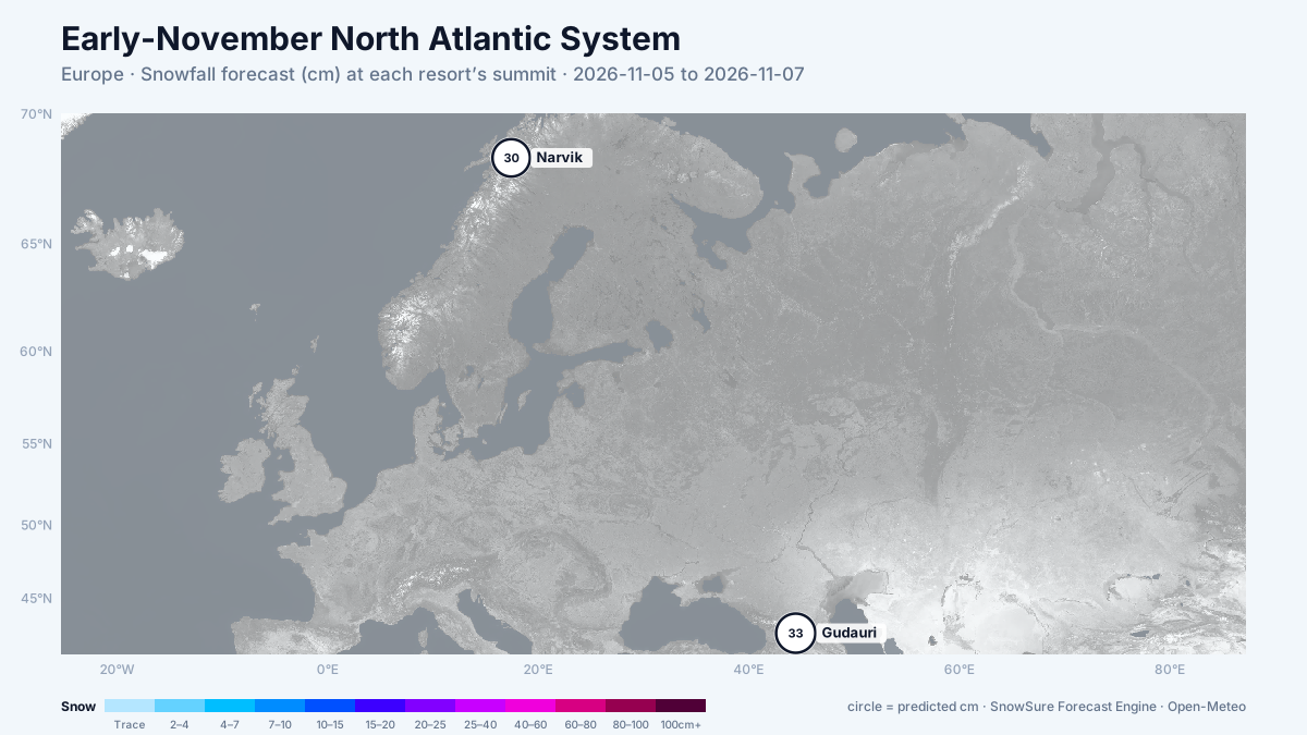
72-hour snowfall forecast for the same window.

In the path
Forecast, not observation — none of this has fallen yet. Totals are across the window. We will post what fell when the window closes.


Last updated 2026-11-01 06:30 UTC. SnowSure scans a blend of seven weather models twice daily and flags systems clearing 30cm over 72 hours, three to fourteen days out. This watch opened on 2026-10-28 with 49cm forecast at Gudauri.


