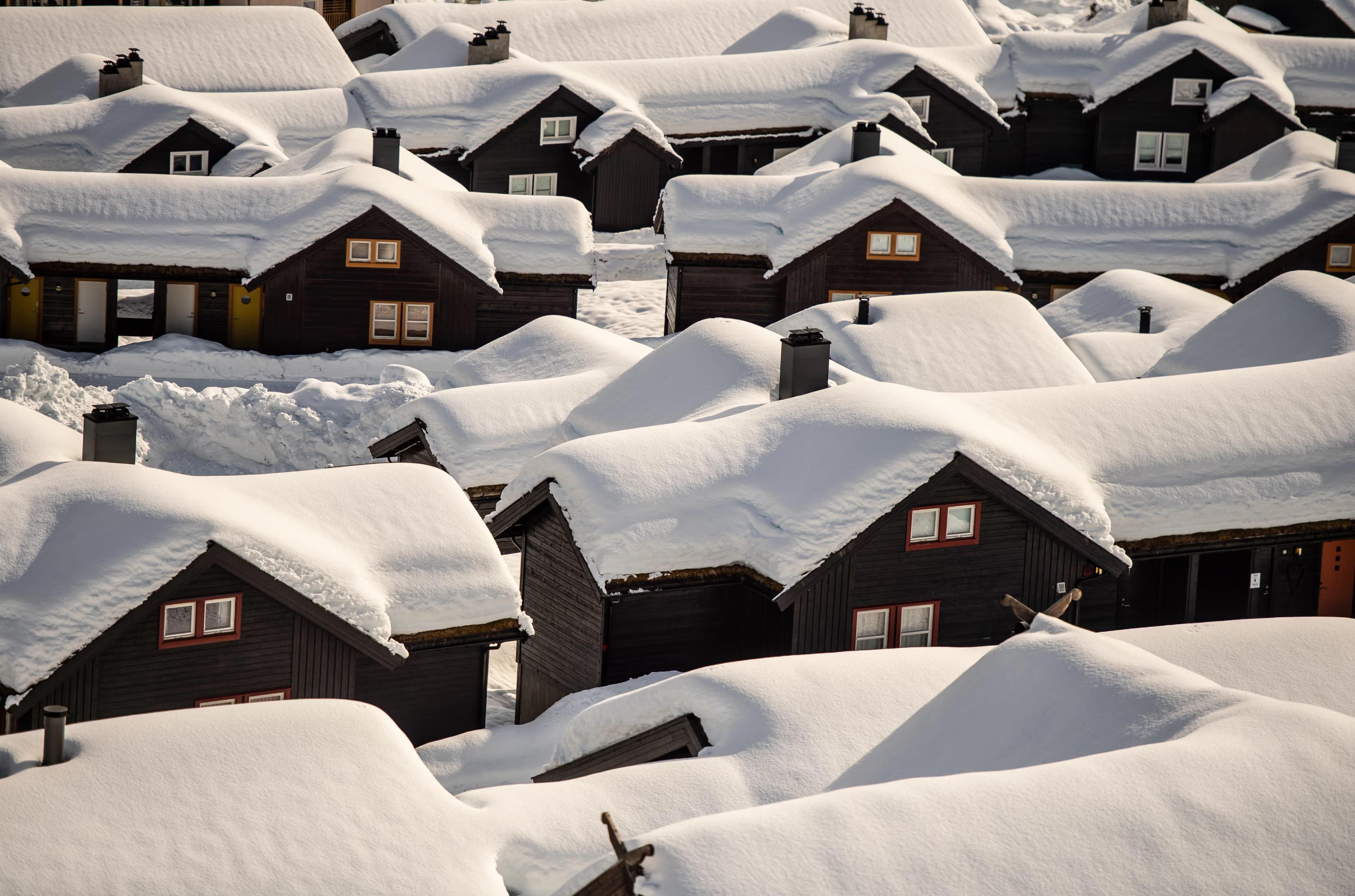
Mid-November North Atlantic System
6 resorts in the path, 30cm at the biggest. Watching — the models see it but do not yet agree closely; likely at 1 of 6 resorts.
+30CM
Predicted at Stranda
2–93cm, models far apart
Storm
Nov 12–17
6 resorts in the path
Peak
Nov 14
13cm at Myrkdalen
Predicted
30cm
Stranda · 2–93cm, models far apart
Confidence
Watching
Likely at 1 of 6 resorts
Updated
Nov 5, 18:30 UTC
SnowSure Forecaster
Written from the blend and the model spread · updated Nov 5, 18:30 UTC
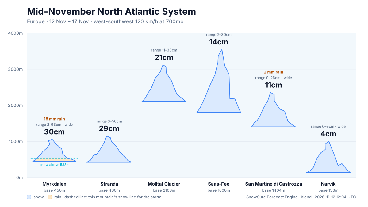
Current prediction: 2–93cm for Myrkdalen between 2026-11-13 and 2026-11-17, 30cm our central figure. The biggest day is 2026-11-14 at 13cm. Also in the path: Stranda 29cm, Mölltal Glacier 21cm, Saas-Fee 14cm, and 2 more. Confidence is watching: the signal has crossed our threshold but the models still disagree on how much. By resort: Likely at 1 of 6 resorts. These figures are re-read from the latest model blend; each entry in the log keeps what we said at the time.
Forecast log
Every entry, newest first. Nothing is overwritten.
- Day 5·Nov 5·Likely·46cm(-19)
Confidence likely: 45.5cm for Stranda Nov 11–14
Day 5: the top total for Stranda is down 19.3cm since the previous entry, but the window has moved one day earlier. We now expect snowfall totals of 45.5cm for Stranda over the window from November 11 to November 14, with the biggest day forecasted for November 12 at 16.9cm. Confidence remains likely, and we are on track with this trend. As we approach the event, we will continue to monitor the models for any changes in timing or totals. The first day of the window is projected to bring 34.7cm, so conditions should be favorable for early season skiing.
Window Nov 11–14 · Stranda
- Day 4·Nov 4·Likely·65cm(+22)
Confidence likely: 64.8cm for Stranda Nov 12–16
Day 4: totals up 21.5cm at Stranda and the window held. The forecast now indicates a window from November 12 to November 16, with Stranda expected to receive 64.8cm of snow during this period, peaking at 23.9cm on November 14. Confidence in this forecast has shifted to likely as models align on the expected totals. We will continue to monitor conditions closely as we approach the event. While Stranda remains the focus, we are not seeing significant totals for other resorts at this time.
Window Nov 12–16 · Stranda
- Day 3·Nov 3·Watching·43cm(+12)
Confidence watching: 43.3cm for Stranda Nov 11–15
Day 3: totals up 11.9cm since the previous entry and the window has slid a day later. We are now looking at a window from November 11 to November 15, with Stranda leading the forecast at 43.3cm, followed by Alpe d'Huez at 34.7cm and Narvik at 31.8cm. Stranda is showing a significant potential with a range of 10.2–122.2cm, while Alpe d'Huez and Narvik have more limited totals. We will continue to monitor the confidence levels, which remain in a watching state, as trends evolve.
Window Nov 11–15 · Stranda
- Day 2·Nov 2·Watching·31cm(-3)
Confidence watching: 31.4cm for Alpe d'Huez Nov 10–12
Day 2: the top total is down 3.3cm since the previous entry, and the window has moved a day earlier. We now predict a window from November 10 to November 12, with Alpe d'Huez expecting 31.4cm of snow, ranging from 9.6 to 47.8cm. The biggest day is forecasted for November 11, with 17.6cm expected. Confidence is currently categorized as watching, indicating that we need to monitor the models closely as trends appear delayed. We will keep an eye on how the forecasts evolve in the coming days.
Window Nov 10–12 · Alpe d'Huez
- Day 1·Nov 1·Likely·35cmFirst prediction
Confidence builds: 34.7cm for Narvik Nov 11–13
The prediction for the mid-November North Atlantic system indicates a total of 34.7cm for Narvik over the window of November 11 to November 13, with a range of 19.1–54cm. The largest daily accumulation is expected on November 13, with 13.9cm likely. This pattern suggests a favorable setup for snowfall across the Alps and wider Europe, with Narvik positioned to benefit significantly from the incoming system. Resorts like Narvik are likely to see solid snowfall, while others may miss out on the heavier totals. If the models shift towards a stronger system or a change in the prevailing patterns, we could see adjustments in the predicted totals.
Window Nov 11–13 · Narvik
Snow by day
Nov 11 – Nov 18, with a day either side. For each resort: where the freeze line sits against the mountain, then what falls — snow in cm, rain in mm — and the day read from those two numbers.
Myrkdalenbase 450 m · summit 1,060 m
30cm snow18mm rain
Modelled at the summit, 1,060 m · snow above 679 m
linem
/ raincm · mm
Wed
Nov 11
—
Thu
Nov 12
Snow
Fri
Nov 13
Dry
Sat
Nov 14
Mixed
Sun
Nov 15
Mixed
Mon
Nov 16
Mixed
Tue
Nov 17
Snow
Wed
Nov 18
Dry
snow Thu, Tue · rain low, snow high Sat, Sun, Mon (above about 679 m)
Strandabase 430 m · summit 1,151 m
29cm snow
Modelled at the summit, 1,151 m · snow to the base
linem
/ raincm · mm
Wed
Nov 11
—
Thu
Nov 12
Snow
Fri
Nov 13
Snow
Sat
Nov 14
Snow
Sun
Nov 15
Snow
Mon
Nov 16
Snow
Tue
Nov 17
Snow
Wed
Nov 18
Snow
snow every day
Mölltal Glacierbase 2,108 m · summit 3,122 m
21cm snow
Modelled at the summit, 3,122 m · snow to the base
linem
/ raincm · mm
Wed
Nov 11
—
Thu
Nov 12
Snow
Fri
Nov 13
Snow
Sat
Nov 14
Dry
Sun
Nov 15
—
Mon
Nov 16
Snow
Tue
Nov 17
Snow
Wed
Nov 18
Snow
snow Thu, Fri, Mon, Tue
Saas-Feebase 1,800 m · summit 3,550 m
14cm snow
Modelled at the summit, 3,550 m · snow to the base
linem
/ raincm · mm
Wed
Nov 11
—
Thu
Nov 12
Snow
Fri
Nov 13
Snow
Sat
Nov 14
Dry
Sun
Nov 15
Dry
Mon
Nov 16
Snow
Tue
Nov 17
Snow
Wed
Nov 18
Snow
snow Thu, Fri, Mon, Tue
San Martino di Castrozzabase 1,404 m · summit 2,357 m
11cm snow29mm rain
Modelled at the summit, 2,357 m · snow above 1,881 m
linem
/ raincm · mm
Wed
Nov 11
—
Thu
Nov 12
Rain
Fri
Nov 13
Mixed
Sat
Nov 14
Dry
Sun
Nov 15
Dry
Mon
Nov 16
Snow
Tue
Nov 17
Mixed
Wed
Nov 18
Mixed
snow Mon · rain low, snow high Fri, Tue (above about 1,881 m) · rain Thu
Narvikbase 136 m · summit 1,006 m
4cm snow
Modelled at the summit, 1,006 m · snow to the base
linem
/ raincm · mm
Wed
Nov 11
—
Thu
Nov 12
Dry
Fri
Nov 13
Dry
Sat
Nov 14
Dry
Sun
Nov 15
Snow
Mon
Nov 16
Snow
Tue
Nov 17
Snow
Wed
Nov 18
Snow
snow Sun, Mon, Tue
snowrain low, snow highraindryThe dots are the freeze line — the height where rain turns to snow. Solid: straight from the models. Hollow: estimated from temperature. Above the summit line it rains on the whole mountain; below the base line it snows all the way down. Blue bars are snow in cm, amber bars rain in mm; the totals above are their sums.
Rain / snow line
Base to summit for each mountain, with the snow line cut across them.
The system
700mb flow — where the storm is, and what is steering it. Pins sized by forecast total.
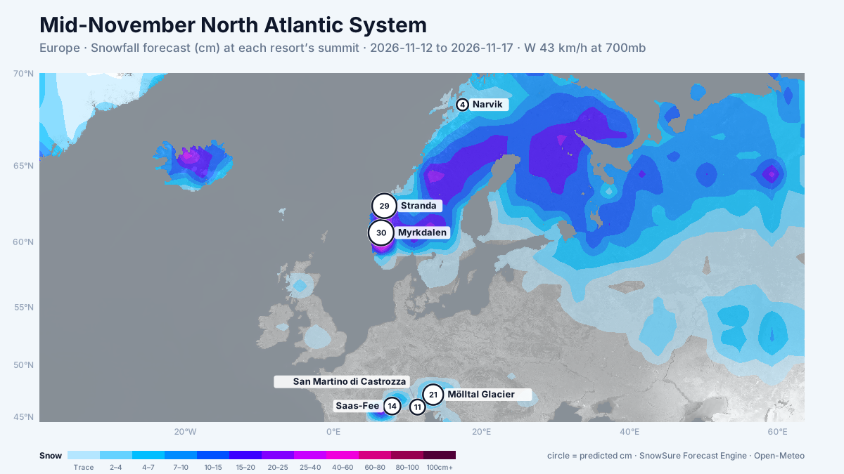
72-hour snowfall forecast for the same window.

In the path
Forecast, not observation — none of this has fallen yet. Totals are across the window. We will post what fell when the window closes.
 LiveMyrkdalenbiggest day 13cm on 14 Nov · newPredicted30cm2–93cm, models far apart
 LiveStrandabiggest day 15cm on 14 Nov · on trackPredicted29cm3–56cm across the models
 LiveMölltal Glacierbiggest day 15cm on 13 Nov · newPredicted21cm11–38cm across the models
 LiveSaas-Feebiggest day 9cm on 17 Nov · newPredicted14cm2–30cm across the models
 LiveSan Martino di Castrozzabiggest day 7cm on 16 Nov · newPredicted11cm0–26cm, models far apart
 LiveNarvikbiggest day 3cm on 15 Nov · delayedPredicted4cm0–9cm, models far apart
When it cleared
When it cleared, all 3 resorts we could read were skiing dry powder. Myrkdalen had the most snow in the window, 30 cm.
3 of 6 resorts in the path · Modeled
Last updated 2026-11-09 18:30 UTC. SnowSure scans a blend of seven weather models twice daily and flags systems clearing 30cm over 72 hours, three to fourteen days out. This watch opened on 2026-11-09 with 45cm forecast at Myrkdalen.


