Late-September Andes System
1 resort in the path, 43cm at the biggest. Watching — the models see it but do not yet agree closely.
+77CM
Predicted at Valle Nevado
34–129cm across the models
Storm
Oct 4–8
1 resort in the path
Peak
Oct 6
26cm at El Colorado
Predicted
77cm
Valle Nevado · 34–129cm across the models
Confidence
Watching
Updated
Oct 2, 00:30 UTC
SnowSure Forecaster
Written from the blend and the model spread · updated Oct 2, 00:30 UTC
Current prediction: 43cm for El Colorado between 2026-10-04 and 2026-10-08, 43cm our central figure. The biggest day is 2026-10-06 at 26cm. El Colorado is the only resort clearing our threshold so far. Confidence is watching: the signal has crossed our threshold but the models still disagree on how much. On day one we said 52cm for El Colorado; that is the number we are measured against. These figures are re-read from the latest model blend; each entry in the log keeps what we said at the time.
Forecast log
Every entry, newest first. Nothing is overwritten.
- Day 11·Oct 2·Likely·77cmLanded
The window opened today. Final prediction: 76.5cm for Valle Nevado, 4–9 Oct.
The window opened today, and we predict 76.5cm for Valle Nevado, 75.4cm for La Parva, 70.9cm for Lagunillas, 69.2cm for Portillo, 47.5cm for Penitentes, and 31.4cm for Volcán Osorno over the period from 2026-10-04 to 2026-10-09. Since our initial forecast on day 1, the top total for Valle Nevado has increased by 18.7cm, and the window start has shifted one day later. Confidence remains likely, with trends on track for most resorts, though we are still watching the situation for Lagunillas and Penitentes.
Window Oct 4–9 · Valle Nevado
- Day 10·Oct 1·Likely·77cm(+19)
Forecast: 76.5cm for Valle Nevado, 4–9 Oct
Day 10: totals up 18.7cm since the previous entry and the window held. We expect significant snowfall across the Andes from October 4 to October 9, with Valle Nevado leading the way at 76.5cm, followed closely by La Parva at 75.4cm. Other resorts like Lagunillas and Portillo are also forecasted to see substantial totals, though confidence remains variable. We will continue to monitor the trends, especially for resorts like Lagunillas and Penitentes, where confidence is still developing.
Window Oct 4–9 · Valle Nevado
- Day 9·Sep 30·Likely·58cm(-24)
Forecast: 57.8cm for Volcán Osorno, 3–8 Oct
Day 9: totals down 23.8cm at Volcán Osorno since the previous entry, and the window start moved a day later. We now predict 57.8cm for Volcán Osorno, with a range of 35.2–99.5cm, peaking on 2026-10-03 at 31.5cm. Other resorts show promising totals as well, with Portillo at 51.6cm and Antillanca at 49.3cm. Confidence remains likely across five of the seven resorts, with trends on track for most. We’ll keep an eye on the strengthening trends at Portillo and Valle Nevado, as well as the new developments at La Parva and Penitentes.
Window Oct 3–8 · Volcán Osorno
- Day 8·Sep 29·Likely·82cm(-4)
Forecast: 81.6cm for Volcán Osorno, 2–6 Oct
Day 8: the top total for Volcán Osorno is down 4.1cm since the previous entry, and the window has shifted one day later. We now expect 81.6cm over the window from 2026-10-02 to 2026-10-06, with the biggest day on 2026-10-03 at 28.7cm. Other resorts show varied totals, with Portillo at 61.9cm and Las Araucarias at 50.3cm, both maintaining likely confidence. Antuco is under watch with a total of 38.5cm. We will continue to monitor trends as we approach the start of the window.
Window Oct 2–6 · Volcán Osorno
- Day 7·Sep 28·Likely·86cm(+5)
Forecast: 85.7cm for Volcán Osorno, 1–7 Oct
Day 7: totals up 12cm since the previous entry and the window held. We are looking at a window from 2026-10-01 to 2026-10-07, with Volcán Osorno leading at 85.7cm, followed by Portillo at 71.2cm and Las Araucarias at 54.5cm. The confidence remains likely for four of the eight resorts, but trends are weakening for Las Araucarias and Antillanca. We will continue to monitor the situation closely, especially as we approach the opening of the window.
Window Oct 1–7 · Volcán Osorno
- Day 6·Sep 27·Likely·81cm(-15)
Forecast: 80.7cm for Portillo, 30 Sep – 8 Oct
Day 6: the top total is down 15.5cm since the previous entry, but the window remains unchanged. We expect 80.7cm for Portillo, with a range of 41.3–131.4cm, peaking on 2026-10-02 at 24.6cm. Other resorts show promising totals, including 71.4cm for Volcán Osorno and 70.5cm for Las Araucarias, both with their biggest days on 2026-10-03. Confidence is likely across five of the nine resorts, and trends are strengthening for most. We’ll be monitoring the developments closely as we approach the window opening in three days.
Window Sep 30–Oct 8 · Portillo
- Day 5·Sep 26·Likely·96cm(+14)
Forecast: 96.2cm for Las Araucarias, 30 Sep – 5 Oct
Day 5: totals up 13.6cm since the previous entry and the window start moved one day later. We now expect 96.2cm for Las Araucarias, 85.7cm for Volcán Osorno, and 65.2cm for Corralco over the window from 2026-09-30 to 2026-10-05. The biggest day is projected for 2026-10-03 at Las Araucarias with 32.3cm. Confidence remains likely across four of the five resorts, with La Parva still under observation. We will continue to monitor developments closely as we approach the event.
Window Sep 30–Oct 5 · Las Araucarias
- Day 4·Sep 25·Likely·83cm(+15)
Forecast: 82.6cm for Volcán Osorno, 29 Sep – 5 Oct
Day 4: totals up 14.5cm since the previous entry and the window start moved one day earlier. We now expect 82.6cm for Volcán Osorno, with a range of 10.5–197.6cm, peaking at 22.6cm on 2026-10-03. Other notable totals include 81.5cm for Las Araucarias and 68.4cm for Corralco, both with strong confidence. As we approach the window, we will continue to monitor trends, especially for Antillanca, which is currently showing a delayed trend.
Window Sep 29–Oct 5 · Volcán Osorno
- Day 3·Sep 24·Likely·68cm(-12)
Forecast: 68.1cm for Corralco, 30 Sep – 5 Oct
Day 3: top total down 11.7cm since the previous entry, and the window start moved one day later. We now expect 68.1cm for Corralco, with totals ranging from 33.2–126.3cm over the window from 2026-09-30 to 2026-10-05. Other resorts like Las Araucarias and Volcán Osorno are also showing promising totals, but confidence is still only likely at six of the nine resorts. We will continue to monitor trends closely, particularly for Antillanca and Lagunillas, which have just been added to our forecast.
Window Sep 30–Oct 5 · Corralco
- Day 2·Sep 23·Watching·80cm(+22)
Forecast: 79.8cm for Corralco, 29 Sep – 4 Oct
Day 2: totals up 22.1cm since the previous entry and the window held. We are now predicting a window from 2026-09-29 to 2026-10-04, with total snowfall estimates of 79.8cm for Corralco, 54.6cm for Volcán Osorno, and 51cm for Antuco. Confidence remains watching, with trends on track for several resorts. We will continue to monitor the situation closely, especially for Las Araucarias and Portillo, where trends are showing signs of weakening. The next few days will be critical as we approach the event window.
Window Sep 29–Oct 4 · Corralco
- Day 1·Sep 22·Watching·58cmFirst prediction
Forecast: 57.7cm for Portillo, 29 Sep – 2 Oct
The prediction for the late-September Andes system indicates Portillo could see 57.7cm of snow, with a range of 7.9–124.4cm. The overall pattern suggests a favorable setup for snowfall across the region, particularly for resorts at higher elevations. Portillo stands out as the likely winner, with strong totals expected, especially on 2026-09-30 when we anticipate 22.4cm. Corralco, Volcán Osorno, and Las Araucarias also show promise, while resorts like Valle Nevado, El Colorado, and Antillanca may see less favorable conditions, with totals in the lower range. Changes in the forecast could arise from shifts in storm intensity or trajectory.
Window Sep 29–Oct 2 · Portillo
Snow by day
Oct 3 – Oct 9, with a day either side. For each resort: where the freeze line sits against the mountain, then what falls — snow in cm, rain in mm — and the day read from those two numbers.
El Coloradobase 2,430 m · summit 3,333 m
—cm snow
no daily data
No daily series on file for these resorts yet.
Rain / snow line
Base to summit for each mountain, with the snow line cut across them.

The system
700mb flow — where the storm is, and what is steering it. Pins sized by forecast total.
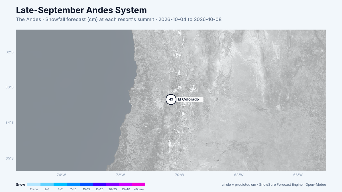
72-hour snowfall forecast for the same window.

In the path
Forecast, not observation — none of this has fallen yet. Totals are across the window. We will post what fell when the window closes.
Last updated 2026-10-04 00:30 UTC. SnowSure scans a blend of seven weather models twice daily and flags systems clearing 30cm over 72 hours, three to fourteen days out. This watch opened on 2026-09-22 with 52cm forecast at El Colorado.


