📷 Awakino
Oceania
Awakino
Limited
→stable
Scroll for happiness
Last Snowfall
Aug 17
4d agoPast 24 Hours
0cm
Past 48 Hours
0cm
Past 10 Days
2.5cm
14-Day Forecast
15cm
Snow Depth
--
Overview
Awakino is a ski resort in Oceania, New Zealand. Today's SnowSure™ Score is 9/100 (Limited), 3 cm (1.2 in) of snow in the last 7 days. The 14-day ensemble forecast across seven weather models (ECMWF, GFS, GEM, JMA, ICON, Météo-France, Met Norway) calls for ~15 cm (5.9 in) of new snow. Conditions last updated 2026-08-21 15:02 UTC.
Resort Guide
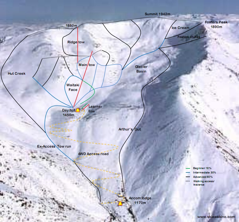
Awakino Ski Area is a club-operated ski field located in the St. Marys Range near Kurow, New Zealand. The area offers a relaxed, uncrowded atmosphere with natural terrain suited for intermediate and advanced skiers, featuring rope tows and a rustic lodge for overnight stays. Managed by volunteers, Awakino emphasizes a traditional, community-driven ski experience with basic amenities and a focus on adventure and camaraderie.
Gallery
Click to expand • 4 total photos
Terrain & lifts
Resort-reported stats for Awakino
Lifts
3
Skiable area
247.1 ac
Resort Info
Season dates
Future dates are operator estimates and may change.
Top Après Ski
Unable to determine top apres ski place for this resort.
Limited conditions.
Awakino is experiencing mainly clear skies with a temperature of -3°C, and has received 3cm of new snow over the past week. The current snow depth is not available, but the season total stands at 51cm, which is 60% of the 5-year average for this time of year.
Depth
No reliable depth reading available.
Recent
No new snow has been recorded in the past 24 or 48 hours, with just 1cm falling over the last week.
Forecast
The 14-day snow outlook suggests an average of 15cm, with some models predicting up to 24cm.
Historic
So far this season, Awakino has received 51cm, which is below the 5-year average of 85cm for this date.
Data updated Fri, Aug 21, 03:02 PM UTC
Snow Summary
Updated Aug 21, 2026 at 3:02 PM
Historical data from Open-Meteo archive • Forecast from ECMWF IFS model
Snowfall Forecast Maps
New Zealand region
Current Conditions
Reported Fri, Aug 21, 03:02 PM UTC
Freezing Level
1435m
❄️ Below base - cold & dry snow expected
Base
1450m
Temp
-0.1°C
Wind
14.3km/h
Snow Depth
--
Open-Meteo model
14-Day Forecast
8.7cm
Mid-Mountain
1665m
Temp
--°C
Wind
16km/h
Snow Depth
--
Open-Meteo model
14-Day Forecast
15cm
Summit
1880m
Temp
-2.9°C
Wind
14.3km/h
Snow Depth
--
Open-Meteo model
14-Day Forecast
14.6cm
Ops signals
- ●Freezing level below base — snowmaking window open
Live Conditions
Awakino Webcams
Awakino Ski Club
Awakino Ski Club
Local Reports
0 reportsDaily Snowfall Forecast by Model
Black line = verified SnowSure™ blend (not a simple average). Weights update weekly from measured snowfall at SNOTEL stations and resort reports.
SnowSure™ blend — verified model weighting
The black line is not a simple average. For Awakino (southern alps), we combine seven global weather models using weights learned from daily forecast verification — comparing each model's prediction to measured snowfall (SNOTEL, resort reports, ERA5).
- 1.Horizon buckets: days 1–3, 4–7, and 8–14 each get separate weights — short-range skill differs from long-range.
- 2.Regional calibration: weights come from verified error in this geography (Rockies, Alps, Japan, etc.), recalculated weekly.
- 3.Ground truth only: we never grade a forecast against another model — only against measured snow.
Building verification history for this resort.
How we verify forecasts →Hourly Forecast Detail
AM / PM / Night breakdown with wind and freezing level
NWP models refresh up to 4× daily · Last synced Aug 21, 3:02 PM
Sat, Aug 22 3 / -3 | Sun, Aug 23 -2 / -62.8cm3.9mm | Mon, Aug 24 2 / -6 | Tue, Aug 25 6 / -31.5cm2.4mm | Wed, Aug 26 -1 / -46.5cm9.3mm | Thu, Aug 27 -3 / -52.8cm3.9mm | |||||||||||||
|---|---|---|---|---|---|---|---|---|---|---|---|---|---|---|---|---|---|---|
| Period | AM | PM | Night | AM | PM | Night | AM | PM | Night | AM | PM | Night | AM | PM | Night | AM | PM | Night |
| Snow (cm) | 0 | 0 | 0 | 1.1 | 0.4 | 1.3 | 0 | 0 | 0 | 0.9 | 0 | 0.6 | 0.4 | 3.9 | 2.2 | 0.9 | 0.4 | 1.5 |
| Precip (mm) | 0 | 0 | 0 | 1.5 | 0.6 | 1.8 | 0 | 0 | 0 | 1.5 | 0.1 | 0.8 | 0.6 | 5.5 | 3.2 | 1.3 | 0.5 | 2.1 |
| Temp (°C) | -2 | 2 | -2 | -3 | -3 | -4 | -2 | 1 | -3 | 1 | 4 | -1 | -2 | -2 | -4 | -5 | -5 | -4 |
| Wind (km/h) | 14 | 16 | 13 | 20 | 25 | 13 | 14 | 25 | 14 | 20 | 22 | 13 | 4 | 3 | 4 | 7 | 8 | 5 |
| Gusts (km/h) | 73 | 70 | 73 | 85 | 106 | 76 | 63 | 94 | 78 | 88 | 94 | 86 | 19 | 22 | 35 | 27 | 38 | 27 |
14-Day Snow Forecast by Model
Summit elevation (1880m)
10-Day Forecast
Sat
22
☁️
3.2°
-3.4°
18 km/h
Sun
23
❄️
-1.7°
-6.5°
2.9cm
27 km/h
Mon
24
⛅
2°
-6.3°
26 km/h
Tue
25
🌧️
5.5°
-3°
25 km/h
Wed
26
❄️
-1.1°
-4.4°
6.2cm
5 km/h
Thu
27
❄️
-2.8°
-5.4°
3.3cm
8 km/h
Fri
28
🌧️
1.8°
-3.4°
12 km/h
Sat
29
🌧️
4.2°
-2.6°
10 km/h
Sun
30
⛅
4.2°
-3.6°
26 km/h
Mon
31
⛅
4°
-3.9°
13 km/h
Summit elevation (1880m) • ECMWF model
Season vs Historic
Updated Fri, Aug 21, 03:02 PM UTC
51.3cm
Season Total
This Season to Date
-40%
vs 5-Year Avg
85cm avg by now
-10%
vs 30-Year Avg
57cm avg by now
85cm
5-Yr Avg by Now
This season is at 51.3 cm to date. The last completed season totaled ~51 cm. That's 40% below the 5-year average (85 cm). Versus the 30-year baseline: 11% below the 30-year average (57 cm).
Awakino Snow History
Average annual snowfall is 106cm with an average of 49 snowfall days per season. The table below shows monthly averages across 31 seasons of archive data (modeled snowpack at mid-elevation).
| Month | Avg Snowfall | Snowfall Days | Avg Base Depth | Max Base Depth | Biggest Snowfall |
|---|---|---|---|---|---|
| June | 17.4cm | 9 days | 5cm | 11cm | 6.9cm |
| July | 24.1cm | 10 days | 9cm | 17cm | 9.2cm |
| August | 18.3cm | 10 days | 7cm | 15cm | 7cm |
| September | 17.5cm | 8 days | 1cm | 7cm | 7.1cm |
| October | 19.5cm | 8 days | 1cm | 8cm | 8.6cm |
Source: SnowSure archive · Open-Meteo ERA5 reanalysis at mid-elevation. Depth is modeled, not resort-reported.
Season at a Glance
Next season(2026)
Opens Jul 1, 2026
Through Oct 15, 2026
Multi-season averages will appear once SnowSure has tracked more than one full season.
ENSO seasonal analog
History · not a forecastIn 5 past El Niño winters at Awakino, ERA5 season snowfall median was 77 cm (30 in), about 16% below this resort’s long-term median. This is a historical analog from reanalysis — not a prediction of this winter’s storm track.
Prevailing ONI
El Niño
MJJ 2026 · ANOM +1.39°C
Analog season median
77 cm
5 El Niño winters · 16% below median
All-season median
92 cm
Across 30 ERA5 seasons (2026)
| Phase | Seasons | Median | p25–p75 | Recent analogs |
|---|---|---|---|---|
| El Niñocurrent | 5 | 77 cm | 61 cm – 92 cm | 2023, 2015, 2009, 2002, 1997 |
| La Niña | 4 | 73 cm | 64 cm – 106 cm | 2022, 2010, 1999, 1998 |
| ENSO-neutral | 21 | 99 cm | 83 cm – 126 cm | 2025, 2024, 2021, 2020, 2019, 2018 |
Season snowfall from Open-Meteo ERA5 reanalysis (~9 km). ENSO phase from NOAA CPC Oceanic Niño Index. Relative phase differences are more trustworthy than absolute cm totals. Source: NOAA CPC Oceanic Niño Index + Open-Meteo ERA5 via SnowSure season archive.
Best Months to Visit
August
Peak Season
July
Peak Season
September
Good
June
Good
Note: Based on typical ski season patterns for this region.
Frequently asked questions about Awakino
- Where is Awakino?
- Awakino is a ski resort in New Zealand.
- How high is Awakino?
- Awakino runs from a base elevation of 1,450 m (4,757 ft) to a summit of 1,880 m (6,168 ft), giving a vertical drop of 430 m (1,411 ft).
- How big is Awakino?
- Awakino has 247 acres (100 hectares) of skiable terrain and 3 lifts.
- When is ski season at Awakino?
- Awakino typically operates from July to October. Exact opening and closing dates shift each year with snowfall — check the resort's current season dates before booking.
- How much snow does Awakino get in a typical season?
- Awakino averages 98 inches / 249 cm of snowfall in a typical season. Any individual season can run well above or below that.