
📷 Caviahue
South America
Caviahue
Outstanding
↗improving
Scroll for happiness
Last Snowfall
Jul 16
todayPast 24 Hours
10.8cm
Past 48 Hours
62.7cm
Past 10 Days
107.5cm
14-Day Forecast
66.1cm
Snow Depth
66cm
Powder Days
17
2026 season
Bluebird Days
2
2026 season
Overview
Caviahue is a ski resort in South America, Argentina. Today's SnowSure™ Score is 74/100 (Outstanding), snow base 66 cm (26 in), 11 cm (4.3 in) of new snow in the last 24 hours. The 14-day ensemble forecast across seven weather models (ECMWF, GFS, GEM, JMA, ICON, Météo-France, Met Norway) calls for ~66 cm (26 in) of new snow. Conditions last updated 2026-07-16 20:02 UTC.
Resort Guide
Caviahue is a ski resort located in the Neuquén province of Argentine Patagonia, set on the slopes of the Copahue Volcano and beside Lake Caviahue. The resort features over 325 hectares of skiable terrain, offering a variety of runs for all levels, as well as snowboarding, snowshoeing, and snowmobile excursions. Its tranquil atmosphere, scenic volcanic landscapes, and geothermal hot springs nearby distinguish Caviahue as a unique destination for winter sports and relaxation. Key amenities include ski and snowboard schools, equipment rentals, and a family-friendly base area.
Gallery
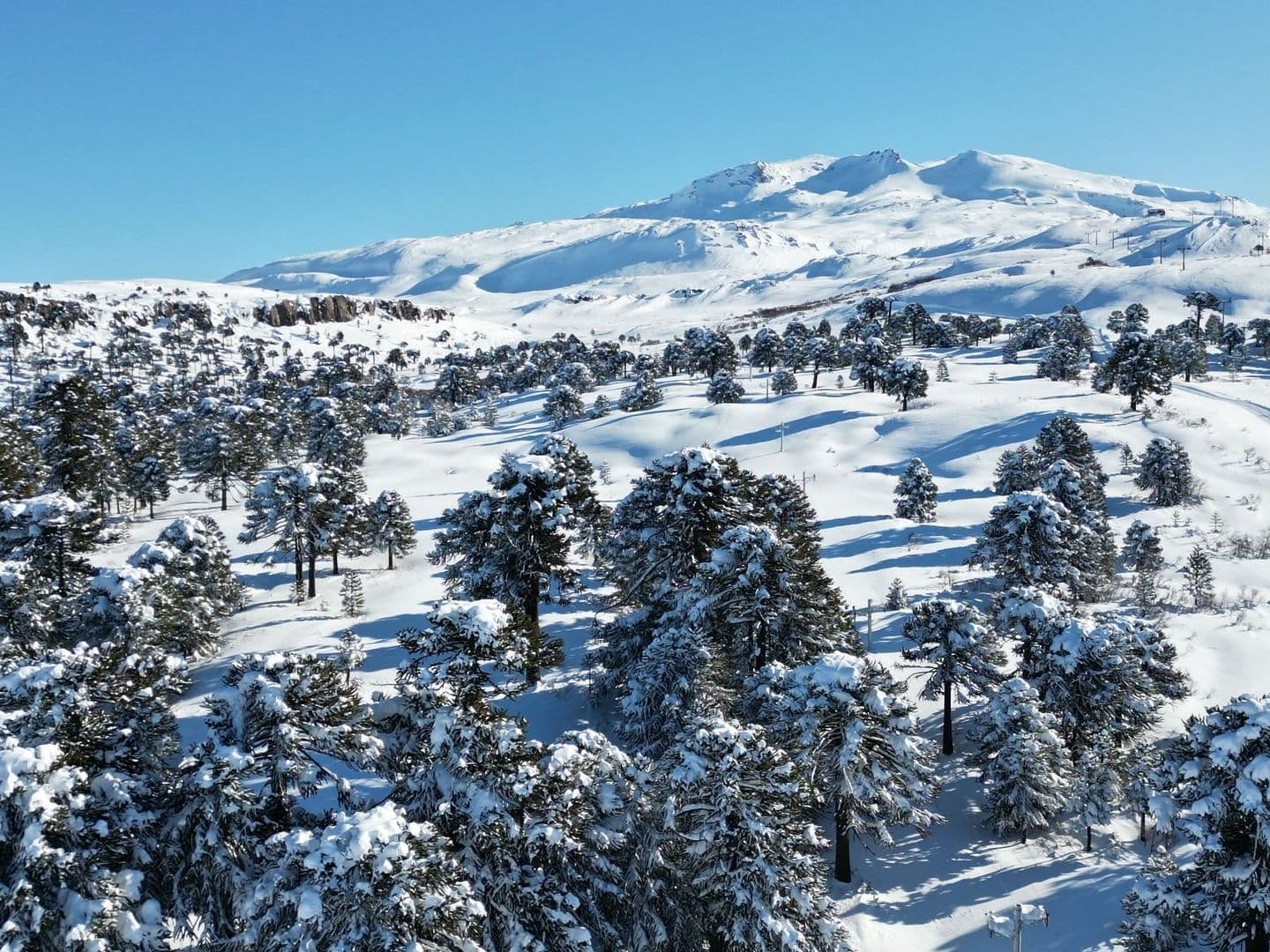
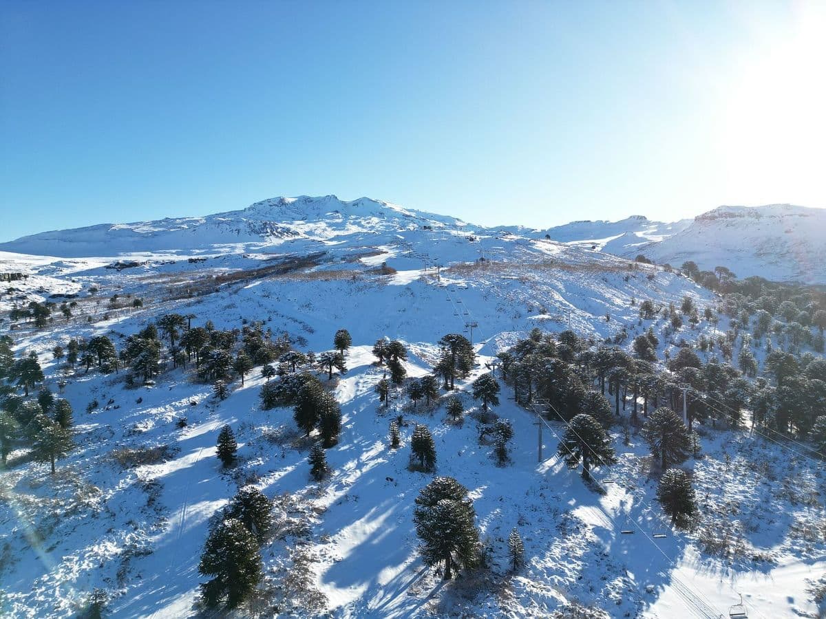
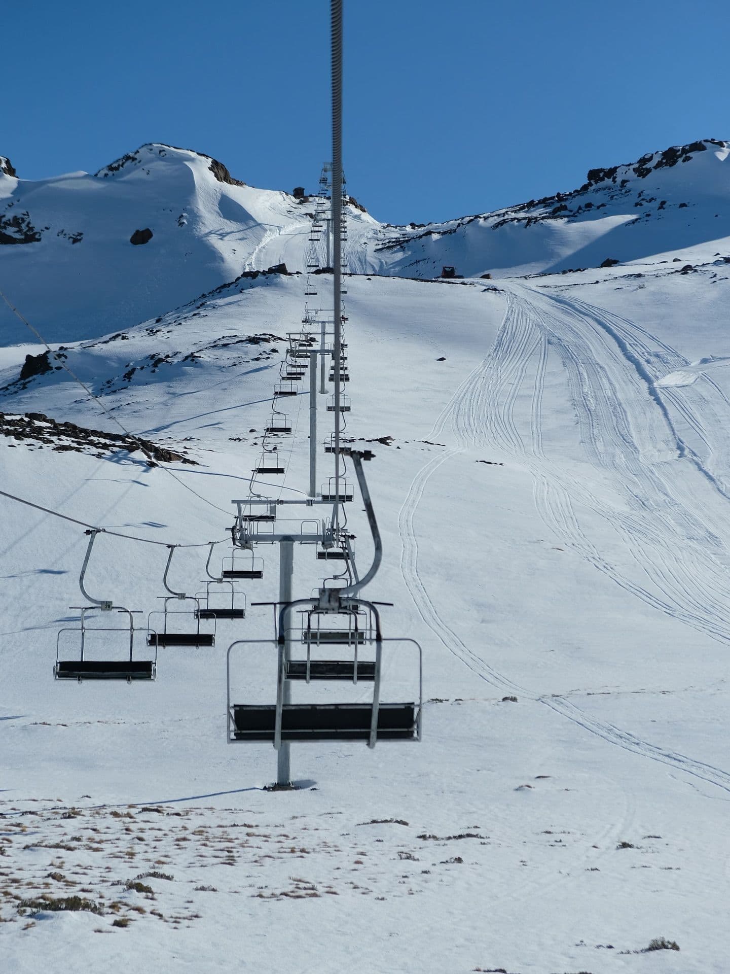
Click to expand • 4 total photos
Terrain & lifts
Resort-reported stats for Caviahue
Lifts
13
Skiable area
152.7 ac
Runs by difficulty(22 total)
Beginner
7
31% of terrain
Intermediate
4
17% of terrain
Advanced
9
42% of terrain
Expert
2
9% of terrain
Run counts estimated from resort-reported totals and terrain mix.
Lift fleet
- Quad chair1
- Double chair1
- Surface lift10
Resort Info
Season dates
Future dates are operator estimates and may change.
Ski passes
No ski pass found
Access tiers change by season — confirm benefits on the pass operator's site.
Top Après Ski
Refugio de Montaña – This cozy mountain refuge is renowned for its warm atmosphere, hearty local cuisine, and welcoming après-ski ambiance, making it a favorite spot for skiers to unwind with drinks and regional specialties after a day on the slopes.
Major snowfall ahead - 152cm forecast.
Caviahue is currently experiencing moderate snowfall with 11cm in the last 24 hours and a total of 88cm over the past week. The snow depth stands at an estimated 66cm, providing a solid base for skiing. Looking ahead, the 14-day forecast suggests potential for an average of 66cm, with some models predicting up to 246cm of additional snow.
AI-generated summaryDepth
66cm depth — good coverage on most runs.
Recent
In the last 7 days, 116cm of snow has fallen.
Forecast
The 14-day snow outlook suggests an average of 73cm of new snow.
Historic
Season-to-date snowfall is at 190cm, which is 78% of the 5-year average of 244cm.
Data updated Thu, Jul 16, 08:02 PM UTC
Snow Summary
Updated Jul 16, 2026 at 8:02 PM
Historical data from Open-Meteo archive • Forecast from ECMWF IFS model
Snowfall Forecast Maps
Andes (Chile & Argentina) region
Current Conditions
Reported Thu, Jul 16, 08:02 PM UTC
Depth by source
every reading we have- Open-MeteoBase 66cm · Summit 66cm
The headline depth uses the most trusted available source. We show every reading so you can judge for yourself.
Freezing Level
2022m
🌡️ Mid-mountain - mixed conditions
Base
1650m
Temp
2.4°C
Wind
22.6km/h
Snow Depth
66cm
Model est.
14-Day Forecast
135.8cm
Mid-Mountain
1859m
Temp
--°C
Wind
25km/h
Snow Depth
66cm
Model est.
14-Day Forecast
66.1cm
Summit
2068m
Temp
-0.3°C
Wind
22.6km/h
Snow Depth
66cm
Model est.
14-Day Forecast
116.2cm
Local Reports
0 reportsDaily Snowfall Forecast by Model
Black line = verified SnowSure™ blend (not a simple average). Weights update weekly from measured snowfall at SNOTEL stations and resort reports.
SnowSure™ blend — verified model weighting
The black line is not a simple average. For Caviahue (andes), we combine seven global weather models using weights learned from daily forecast verification — comparing each model's prediction to measured snowfall (SNOTEL, resort reports, ERA5).
- 1.Horizon buckets: days 1–3, 4–7, and 8–14 each get separate weights — short-range skill differs from long-range.
- 2.Regional calibration: weights come from verified error in this geography (Rockies, Alps, Japan, etc.), recalculated weekly.
- 3.Ground truth only: we never grade a forecast against another model — only against measured snow.
Building verification history for this resort.
How we verify forecasts →Hourly Forecast Detail
AM / PM / Night breakdown with wind and freezing level
NWP models refresh up to 4× daily · Last synced Jul 16, 8:02 PM
Today 1 / -117.3cm24.7mm | Fri, Jul 17 -1 / -313.7cm19.5mm | Sat, Jul 18 -2 / -54cm5.6mm | Sun, Jul 19 -3 / -90.8cm1.1mm | Mon, Jul 20 -2 / -61.3cm1.9mm | Tue, Jul 21 -4 / -74.3cm6mm | |||||||||||||
|---|---|---|---|---|---|---|---|---|---|---|---|---|---|---|---|---|---|---|
| Period | AM | PM | Night | AM | PM | Night | AM | PM | Night | AM | PM | Night | AM | PM | Night | AM | PM | Night |
| Snow (cm) | 2.9 | 3.6 | 10.8 | 0.5 | 1.2 | 12 | 0.4 | 1.6 | 2 | 0.1 | 0 | 0.7 | 0.7 | 0.1 | 0.5 | 2.5 | 1.5 | 0.3 |
| Precip (mm) | 4.1 | 5.2 | 15.4 | 0.7 | 1.7 | 17.1 | 0.5 | 2.3 | 2.8 | 0.1 | 0 | 1 | 1 | 0.2 | 0.7 | 3.5 | 2.1 | 0.4 |
| Temp (°C) | 0 | 0 | 0 | -3 | -1 | -2 | -3 | -3 | -4 | -7 | -4 | -4 | -4 | -3 | -4 | -6 | -5 | -6 |
| Wind (km/h) | 13 | 24 | 9 | 7 | 4 | 7 | 20 | 9 | 7 | 2 | 5 | 4 | 4 | 4 | 4 | 9 | 5 | 5 |
| Gusts (km/h) | 56 | 83 | 48 | 31 | 22 | 25 | 66 | 42 | 34 | 14 | 15 | 18 | 43 | 51 | 31 | 25 | 37 | 30 |
14-Day Snow Forecast by Model
Summit elevation (2068m)
10-Day Forecast
Today
16
❄️
0.9°
-1.4°
13.6cm
27 km/h
Fri
17
❄️
-1.2°
-3.2°
15.9cm
9 km/h
Sat
18
❄️
-2.4°
-4.9°
6cm
22 km/h
Sun
19
❄️
-2.9°
-9°
0.6cm
6 km/h
Mon
20
❄️
-2.2°
-5.8°
1.7cm
6 km/h
Tue
21
❄️
-4°
-7.3°
4cm
9 km/h
Wed
22
❄️
-3.4°
-7.8°
21.6cm
15 km/h
Thu
23
❄️
-1.5°
-4.4°
4.8cm
17 km/h
Fri
24
❄️
-1.9°
-3.6°
25.1cm
11 km/h
Sat
25
❄️
-0.8°
-5.8°
1cm
12 km/h
Summit elevation (2068m) • ECMWF model
Season vs Historic
Updated Thu, Jul 16, 08:02 PM UTC
192.4cm
Season Total
This Season to Date
-21%
vs 5-Year Avg
244cm avg by now
-21%
vs 30-Year Avg
244cm avg by now
244cm
5-Yr Avg by Now
Snowfall over the past five years has averaged 273.9 cm, significantly exceeding the 30-year average of 173.6 cm, indicating a marked upward trend in recent seasons. The 2023 season stands out as an anomaly with 458.7 cm, nearly double the 5-year average, while 2020 and 2024 were notably below both short- and long-term averages. The current season's snowfall is 52% below the recent 5-year average and 81% below the 30-year average, reflecting a sharp decline from the elevated snowfall observed in recent years. Overall, while the long-term trend has been upward, the current season represents a significant drop relative to both short- and long-term norms.
Caviahue Snow History
Average annual snowfall is 523cm with an average of 77 snowfall days per season. The table below shows monthly averages across 31 seasons of archive data (modeled snowpack at mid-elevation).
| Month | Avg Snowfall | Snowfall Days | Avg Base Depth | Max Base Depth | Biggest Snowfall |
|---|---|---|---|---|---|
| June | 151.3cm | 17 days | 53cm | 100cm | 33cm |
| July | 121.2cm | 16 days | 106cm | 135cm | 30.4cm |
| August | 129.7cm | 17 days | 142cm | 179cm | 32cm |
| September | 69.7cm | 13 days | 149cm | 175cm | 20.9cm |
| October | 40.8cm | 10 days | 116cm | 144cm | 14.1cm |
Source: SnowSure archive · Open-Meteo ERA5 reanalysis at mid-elevation. Depth is modeled, not resort-reported.
Season at a Glance
Next season(2026)
Opens Jun 13, 2026
Through Sep 30, 2026
Multi-season averages will appear once SnowSure has tracked more than one full season.
Best Months to Visit
August
Peak Season
July
Peak Season
September
Good
June
Good
Note: Based on typical ski season patterns for this region.


