
📷 Las Leñas
South America
Las Leñas
Superb · 2026 season average
Projected to open July 2027 · average of 78 verified open days
Best months to book: August, July, September · last season + 30-yr record
Scroll for happiness
Projected to open Jul 2027 — closed September 26
Weather data is still collected for informational purposes.
Last Snowfall
Oct 12
todayPast 24 Hours
0cm
Past 48 Hours
2cm
Past 10 Days
80cm
7-Day Forecast
5cm
Snow Depth
--
Powder Days
63
2026 season
Bluebird Days
7
2026 season
Local Snow
SnowSure Forecaster · October 12, 2026 · How we forecast →
5cm forecast over the next 7 days
Las Leñas is looking at 5.1cm over the next 7 days, with the biggest day on Monday.
Short-Term Forecast
The multi-model blend shows 4.3cm over the next 72 hours (Monday 1.8cm, Tuesday 1.6cm, Wednesday 0.9cm). The biggest day is Monday at 1.8cm.
Extended Forecast
The 7-day window totals 5.1cm. Models disagree by 17.2cm on the window total (5.6 models contributing on average), so treat the figures as a range rather than a promise. Best window: Monday.
Yesterday: Snow on the way for Las Leñas this week
Superb
2026 season average
Las Leñas is projected to open July 2027. Last season it averaged 74.3 across 78 verified open days.
Best months to book
- #1August104cm avg · last season 77.5
- #2July88cm avg · last season 77
- #3September59cm avg · last season 68.4
Best weeks to book
- #1 1 Aug – 7 Aug · last season 88.9
- #2 8 Aug – 14 Aug · last season 78.1
- #3 15 Aug – 21 Aug · last season 74.9
Ranked on 25% last season's SnowSure score (2026) · 75% 30-year snowfall and base-depth record. Last season's strongest fortnight was 24 Jul – 6 Aug. One season describes what happened, not what to expect. The live score returns when the lifts turn.
Current Conditions
Reported Mon, Oct 12, 08:01 PM UTC
Terrain Open
Projected to open Jul 2027
Projected to open July 2027 · season ended September 26, 2026
27 runs · 16 lifts — live counts and the SnowSure™ Score return when the lifts turn.
- Lifts– / 16
- Runs– / 27
Days 8–14 and every model are in SnowSure Pro.
Unlock with ProHistorical data from Open-Meteo archive • Forecast: SnowSure™ multi-model blend
Maps
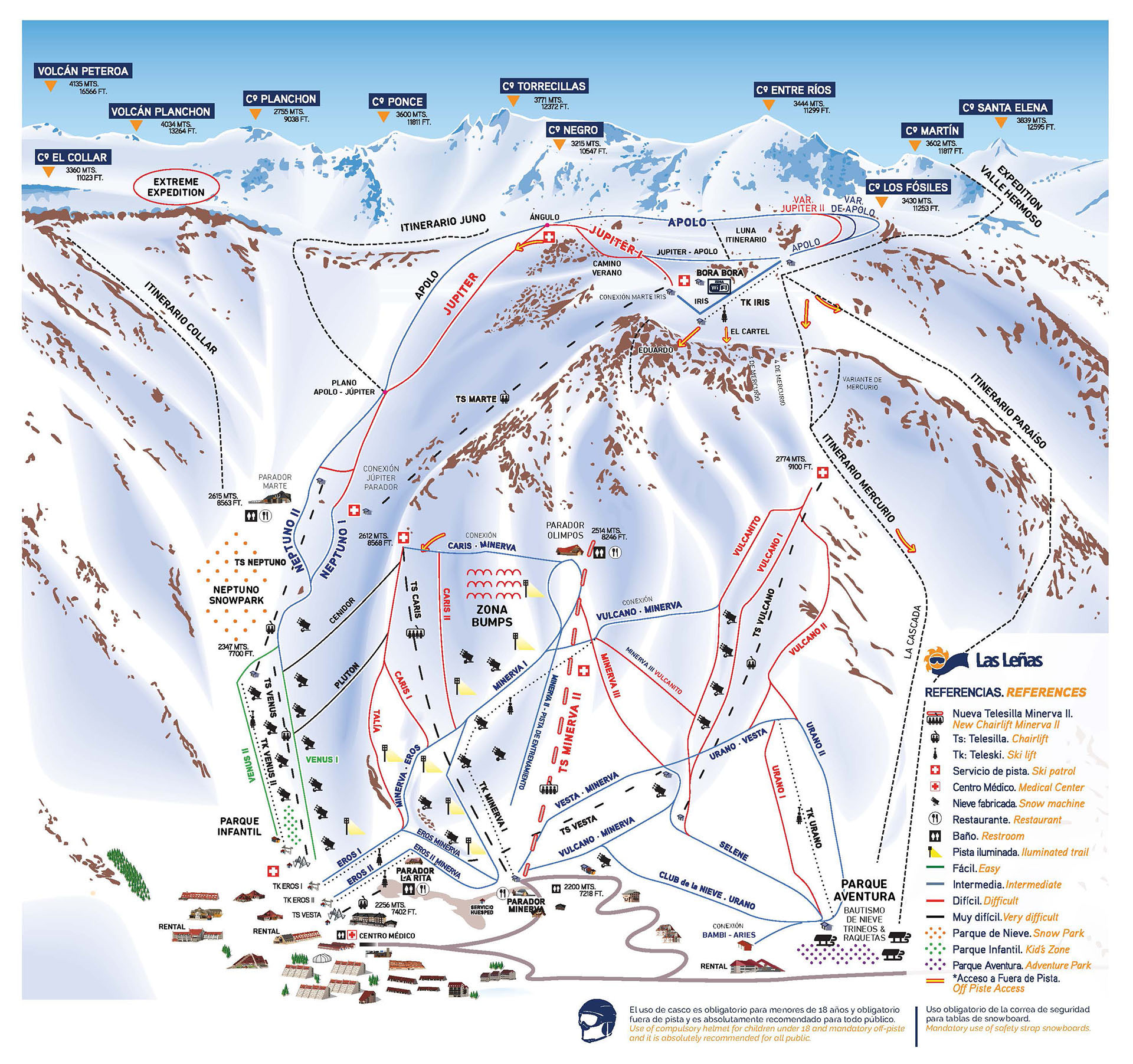
All maps for Las Leñas →
Webcams & Proof of Powder
All webcams & Proof of Powder →

About Las Leñas
Las Leñas is a major ski resort located in the Argentine Andes, in the province of Mendoza. The resort features over 7,000 hectares of skiable terrain, offering a mix of wide-open slopes and challenging off-piste areas suitable for all levels, with a particular reputation for advanced and expert skiing. Guests can enjoy a modern base village with hotels, restaurants, and après-ski options, as well as amenities such as ski schools and equipment rentals. Las Leñas stands out for its high-altitude setting, reliable snow conditions, and expansive backcountry access.
Read the full resort guide →Frequently asked questions about Las Leñas
- Where is Las Leñas?
- Las Leñas is a ski resort in Argentina.
- How high is Las Leñas?
- Las Leñas runs from a base elevation of 2,240 m (7,349 ft) to a summit of 3,430 m (11,253 ft), giving a vertical drop of 1,190 m (3,904 ft).
- How big is Las Leñas?
- Las Leñas has 1,700 acres (688 hectares) of skiable terrain, 27 marked runs and 16 lifts.
- When is ski season at Las Leñas?
- Las Leñas typically operates from June to September. Exact opening and closing dates shift each year with snowfall — check the resort's current season dates before booking.
- How much snow does Las Leñas get in a typical season?
- Las Leñas averages 250 inches / 635 cm of snowfall in a typical season. Any individual season can run well above or below that.
- How will El Niño affect Las Leñas in winter 2026?
- El Niño Signal Rank: #3 of 488 SnowSure resorts · Tier A · strong-event signal +68% vs its own 30-yr average. In the three strongest El Niño winters on record ('97-98, '15-16, '23-24), Las Leñas averaged +68% versus its own 30-year snowfall baseline. The pattern has historically been a friend here. With a record-strength event forecast for winter 2026, Las Leñas sits on the favorable side of the ledger. Analog winters: '97-98 +54%, '15-16 +3%, '23-24 +147%. A pattern, not a promise.


