
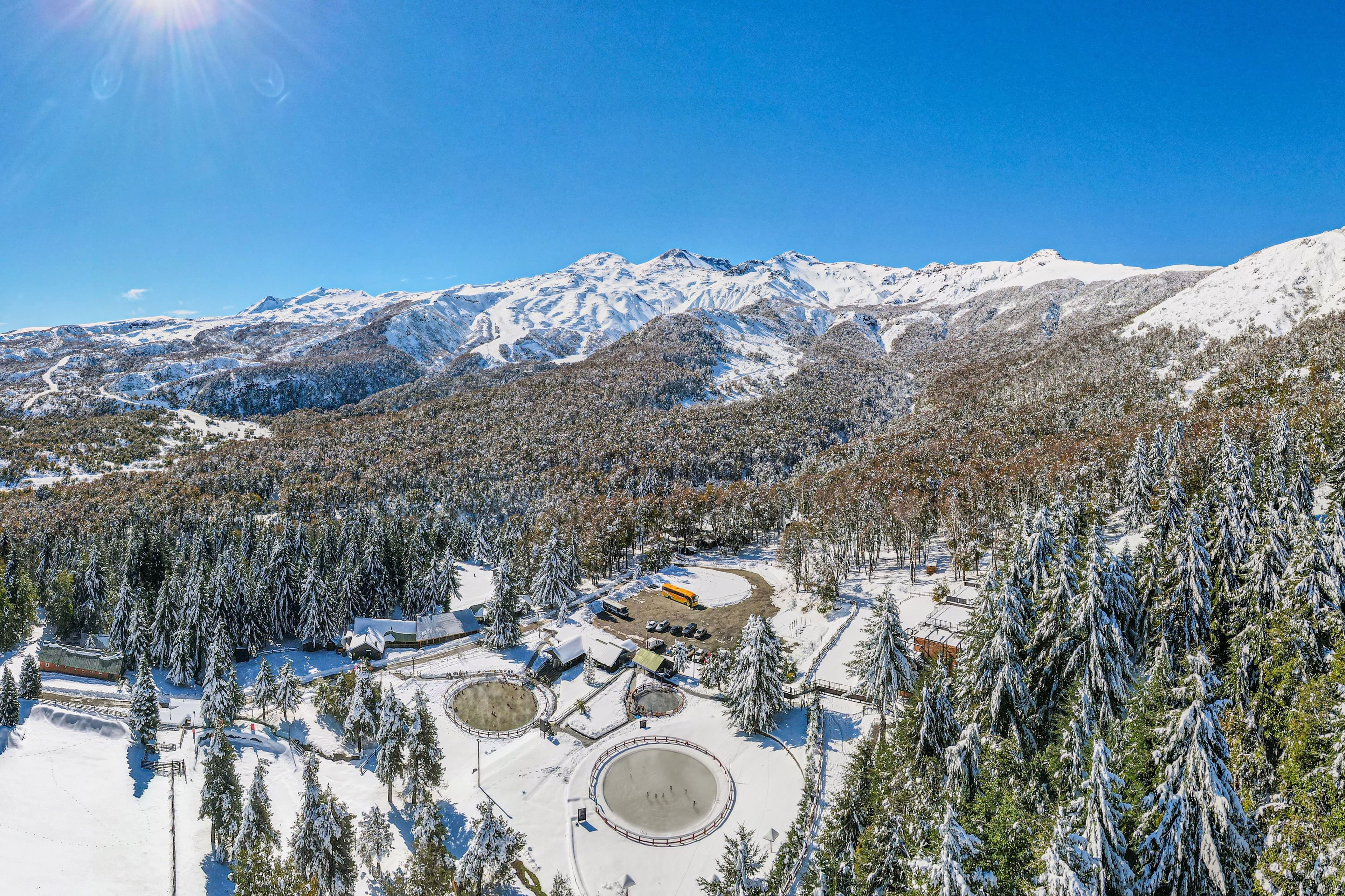
📷 Nevados de Chillán
South America
Nevados de Chillán
Fair
→stable
Scroll for happiness
Last Snowfall
Jun 27
7d agoPast 24 Hours
0cm
Past 48 Hours
0cm
Past 10 Days
7.5cm
14-Day Forecast
65.6cm
Snow Depth
3cm
Powder Days
4
2026 season
Bluebird Days
1
2026 season
Overview
Nevados de Chillán is a ski resort in South America, Chile. Today's SnowSure™ Score is 27/100 (Fair), snow base 3 cm (1.2 in). The 14-day ensemble forecast across seven weather models (ECMWF, GFS, GEM, JMA, ICON, Météo-France, Met Norway) calls for ~66 cm (26 in) of new snow. Conditions last updated 2026-07-04 16:04 UTC.
Resort Guide
Nevados de Chillán is a ski resort located in the Andes of southern Chile, offering over 10,000 hectares of skiable terrain with a mix of groomed runs and off-piste areas. The resort is known for its natural hot springs, volcanic landscapes, and extensive network of trails suitable for all levels. Key amenities include a modern hotel, thermal pools, and a variety of winter sports activities, making it a distinctive destination for both skiing and relaxation in a scenic mountain setting.
Gallery
Click to expand • 4 total photos
Terrain & lifts
Resort-reported stats for Nevados de Chillán
Lifts
16
Skiable area
213.7 ac
Longest run
13 km / 8.1 mi
Runs by difficulty(23 total)
Beginner
6
25% of terrain
Intermediate
10
45% of terrain
Advanced
7
30% of terrain
Run counts estimated from resort-reported totals and terrain mix.
Lift fleet
- Gondola1
- Double chair6
- Surface lift6
Resort Info
Season dates
Future dates are operator estimates and may change.
Ski passes
No ski pass found
Access tiers change by season — confirm benefits on the pass operator's site.
Top Après Ski
Bar La Garganta – Renowned for its cozy alpine ambiance and panoramic mountain views, Bar La Garganta is the go-to après-ski spot at Nevados de Chillán, offering craft cocktails, local wines, and a lively atmosphere perfect for unwinding after a day on the slopes.
Major snowfall ahead - 84cm forecast.
As we begin the ski season at Nevados de Chillán, recent weather has brought light snow, contributing to a limited base. The forecast indicates promising snowfall in the coming weeks. Conditions remain overcast with cool temperatures.
AI-generated summaryDepth
3cm depth — upper mountain may be better.
Recent
In the last week, there has been a total of 18cm of snowfall.
Forecast
The 14-day snow outlook averages around 13cm, providing some anticipation for the upcoming days.
Historic
Season-to-date totals are at 38cm, which is in line with early season expectations compared to the 5-year average of 191cm.
Data updated Sat, Jul 4, 04:04 PM UTC
Snow Summary
Updated Jul 4, 2026 at 4:04 PM
Historical data from Open-Meteo archive • Forecast from ECMWF IFS model
Snowfall Forecast Maps
Andes (Chile & Argentina) region
Current Conditions
Reported Sat, Jul 4, 04:04 PM UTC
Depth by source
every reading we have- Open-MeteoBase 3cm · Summit 3cm
The headline depth uses the most trusted available source. We show every reading so you can judge for yourself.
Freezing Level
2236m
🌡️ Mid-mountain - mixed conditions
Base
1600m
Temp
4.1°C
Wind
7.4km/h
Snow Depth
3cm
Model est.
14-Day Forecast
21.7cm
Mid-Mountain
2050m
Temp
--°C
Wind
8km/h
Snow Depth
3cm
Model est.
14-Day Forecast
65.6cm
Summit
2499m
Temp
-1.7°C
Wind
7.4km/h
Snow Depth
3cm
Model est.
14-Day Forecast
83.7cm
Lifts Open
open
Runs Open
Live Conditions
Nevados de Chillán Webcams
Nevados de Chillán
Nevados de Chillán
Local Reports
0 reportsDaily Snowfall Forecast by Model
Black line = verified SnowSure™ blend (not a simple average). Weights update weekly from measured snowfall at SNOTEL stations and resort reports.
SnowSure™ blend — verified model weighting
The black line is not a simple average. For Nevados de Chillán (andes), we combine seven global weather models using weights learned from daily forecast verification — comparing each model's prediction to measured snowfall (SNOTEL, resort reports, ERA5).
- 1.Horizon buckets: days 1–3, 4–7, and 8–14 each get separate weights — short-range skill differs from long-range.
- 2.Regional calibration: weights come from verified error in this geography (Rockies, Alps, Japan, etc.), recalculated weekly.
- 3.Ground truth only: we never grade a forecast against another model — only against measured snow.
Building verification history for this resort.
How we verify forecasts →Hourly Forecast Detail
AM / PM / Night breakdown with wind and freezing level
NWP models refresh up to 4× daily · Last synced Jul 4, 4:04 PM
Today -2 / -11 | Sun, Jul 5 -1 / -11 | Mon, Jul 6 7 / -10 | Tue, Jul 7 3 / -28.4cm13.5mm | Wed, Jul 8 1 / -244.6cm63.9mm | Thu, Jul 9 2 / -28.9cm12.9mm | |||||||||||||
|---|---|---|---|---|---|---|---|---|---|---|---|---|---|---|---|---|---|---|
| Period | AM | PM | Night | AM | PM | Night | AM | PM | Night | AM | PM | Night | AM | PM | Night | AM | PM | Night |
| Snow (cm) | 0 | 0 | 0 | 0 | 0 | 0 | 0 | 0 | 0 | 3.4 | 0.8 | 4.2 | 15.7 | 11.5 | 17.4 | 1.3 | 0.2 | 7.4 |
| Precip (mm) | 0 | 0 | 0 | 0 | 0 | 0 | 0 | 0 | 0 | 4.8 | 2.7 | 6 | 22.5 | 16.5 | 24.9 | 1.8 | 0.6 | 10.5 |
| Temp (°C) | -8 | -3 | -9 | -6 | -2 | -10 | -4 | 4 | -5 | -2 | 1 | -1 | 1 | 0 | 0 | 0 | 1 | -1 |
| Wind (km/h) | 4 | 6 | 3 | 2 | 4 | 4 | 4 | 8 | 6 | 9 | 12 | 12 | 20 | 21 | 16 | 9 | 16 | 14 |
| Gusts (km/h) | 18 | 23 | 17 | 10 | 17 | 13 | 14 | 24 | 19 | 34 | 37 | 43 | 72 | 55 | 60 | 51 | 42 | 45 |
14-Day Snow Forecast by Model
Summit elevation (2499m)
10-Day Forecast
Today
4
☁️
-1.7°
-11.2°
0.1cm
8 km/h
Sun
5
⛅
-1.1°
-11.2°
6 km/h
Mon
6
☁️
6.8°
-9.7°
11 km/h
Tue
7
🌧️
2.7°
-2.2°
15 km/h
Wed
8
🌧️
0.8°
-1.6°
48.3cm
21 km/h
Thu
9
🌧️
2°
-2.1°
21 km/h
Fri
10
🌧️
2°
-6.2°
15 km/h
Sat
11
🌧️
3°
-6.4°
11 km/h
Sun
12
🌧️
-0.1°
-3.8°
32.5cm
20 km/h
Mon
13
❄️
-4.2°
-7.5°
9.9cm
15 km/h
Summit elevation (2499m) • ECMWF model
Season vs Historic
Updated Sat, Jul 4, 04:04 PM UTC
13.7cm
Season Total
This Season to Date
-94%
vs 5-Year Avg
239cm avg by now
-94%
vs 30-Year Avg
239cm avg by now
239cm
5-Yr Avg by Now
Over the past five years, average seasonal snowfall has nearly doubled the 30-year average, indicating a significant upward trend. The 2023 season stands out as an anomaly with exceptionally high snowfall (503.1 cm), while 2020 saw a notable low (141.4 cm). The most recent season's snowfall is 33% above the 5-year average and 64% above the 30-year average, reinforcing the pattern of increased snowfall in recent years. Variability remains high, but the overall direction is a marked increase compared to long-term historical norms.
Nevados de Chillán Snow History
Average annual snowfall is 548cm with an average of 68 snowfall days per season. The table below shows monthly averages across 31 seasons of archive data (modeled snowpack at mid-elevation).
| Month | Avg Snowfall | Snowfall Days | Avg Base Depth | Max Base Depth | Biggest Snowfall |
|---|---|---|---|---|---|
| June | 154.5cm | 15 days | 59cm | 111cm | 30.2cm |
| July | 133.3cm | 15 days | 121cm | 159cm | 28.9cm |
| August | 136.5cm | 15 days | 159cm | 201cm | 29.1cm |
| September | 79.7cm | 11 days | 163cm | 197cm | 21.9cm |
| October | 41.1cm | 9 days | 117cm | 154cm | 15.6cm |
Source: SnowSure archive · Open-Meteo ERA5 reanalysis at mid-elevation. Depth is modeled, not resort-reported.
Season at a Glance
Current season(2026)
Opened Jun 27, 2026
Scheduled close: Oct 11, 2026
Multi-season averages will appear once SnowSure has tracked more than one full season.
Best Months to Visit
August
Peak Season
July
Peak Season
September
Good
June
Good
Note: Based on typical ski season patterns for this region.


