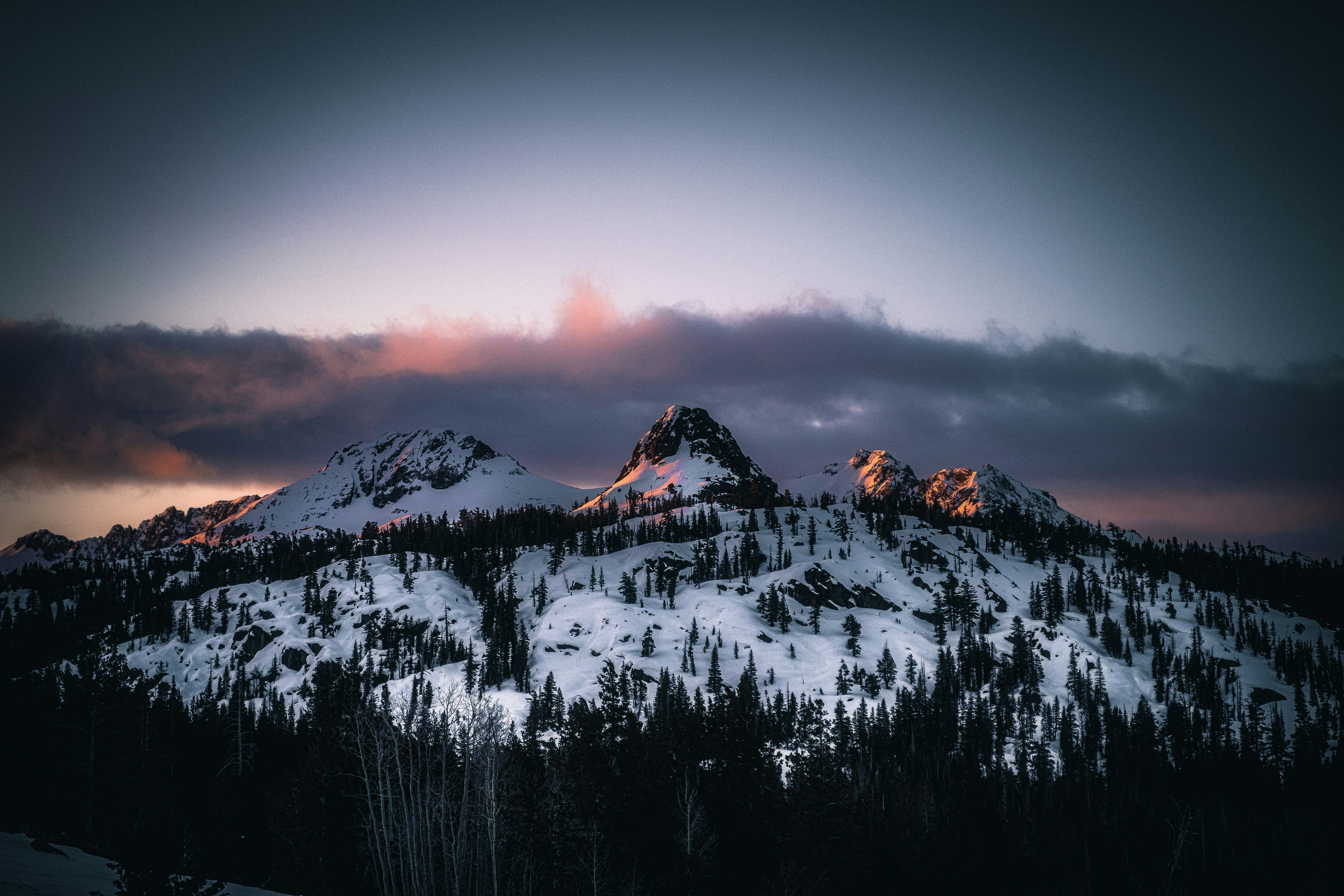
Early-November Pacific System
14 resorts in the path, 55cm at the biggest. Watching — the models see it but do not yet agree closely; likely at 1 of 14 resorts.
+55CM
Predicted at China Peak
29–105cm across the models
Storm
Nov 12–17
14 resorts in the path
Peak
Nov 13
34cm at Kirkwood
Predicted
55cm
China Peak · 29–105cm across the models
Confidence
Watching
Likely at 1 of 14 resorts
Updated
Nov 12, 12:30 UTC
SnowSure Forecaster
Written from the blend and the model spread · updated Nov 12, 12:30 UTC
Current prediction: 29–105cm for Kirkwood between 2026-11-12 and 2026-11-16, 55cm our central figure. The biggest day is 2026-11-13 at 34cm. Also in the path: Bear Valley 44cm, Sugar Bowl 38cm, Boreal Mountain Resort 36cm, and 10 more. Confidence is watching: the signal has crossed our threshold but the models still disagree on how much. By resort: Likely at 1 of 14 resorts. On day one we said 65cm for Kirkwood; that is the number we are measured against. These figures are re-read from the latest model blend; each entry in the log keeps what we said at the time.
Forecast log
Every entry, newest first. Nothing is overwritten.
- Day 12·Nov 12·Watching·93cm(-34)
Day 12: totals down 34.2cm at Alyeska and the window held
Day 12: totals down 34.2cm at Alyeska and the window held. The new window for the mid-November Pacific System is now set from 2026-11-16 to 2026-11-22, with predicted totals of 92.7cm for China Peak and 85.8cm for Dodge Ridge. Confidence is currently watching at 5 of 17 resorts, with trends strengthening for several key locations. We are particularly monitoring Mammoth Mountain and Brighton, both showing promising signs for significant snowfall. As we approach the window, we will keep an eye on any changes in the forecast, especially regarding timing and intensity.
Window Nov 16–22 · China Peak
- Day 11·Nov 11·Likely·127cm(+22)
Day 11: totals up 22.4cm at Alyeska and the window held
The window has shifted one day later, now running from 2026-11-14 to 2026-11-22. Totals have increased, with Alyeska Resort leading at 126.9cm, up 22.4cm since the last entry. Overall, confidence remains likely across the board, with trends strengthening for several resorts. We expect significant snowfall, particularly on 2026-11-19, when Alyeska could see its biggest day at 34.1cm. Other resorts like Wolf Creek and Brian Head are also poised for notable totals, with ranges indicating potential for 61.8cm and 51.5cm, respectively. We will continue to monitor developments closely as the event approaches.
Window Nov 14–22 · Alyeska Resort
- Day 10·Nov 10·Likely·105cm(+29)
Day 10: totals up 29.1cm at Kirkwood and the window held
Day 10: totals up 29.1cm at Kirkwood and the window held. The current prediction for the mid-November Pacific system shows a window from 2026-11-13 to 2026-11-21, with totals expected to reach 104.5cm at Kirkwood, 103.9cm at Bear Valley, and 85.9cm at Dodge Ridge. Confidence is likely at 9 of the 13 resorts, with trends on track for most. We are also seeing strengthening trends at Wolf Creek Ski Area. As we approach the start of the window, we will be monitoring the timing and intensity of the incoming system closely.
Window Nov 13–21 · Kirkwood
- Day 9·Nov 9·Watching·75cm(+3)
Day 9: totals up 3.1cm at Alyeska Resort and the window held
Day 9: totals are up 3.1cm at Alyeska Resort since the previous entry, and the window has shifted to 2026-11-13 to 2026-11-20. We are currently forecasting 75.4cm for Alyeska Resort, with a range of 8–152.7cm, and the biggest day expected on 2026-11-19 at 37.3cm. Overall, we see likely confidence at 6 of the 12 resorts, with trends strengthening for some areas. We will continue to monitor the situation closely as we approach the window opening.
Window Nov 13–20 · Alyeska Resort
- Day 8·Nov 8·Likely·72cm(+18)
Day 8: totals up 18cm, 34–115cm for Whistler Blackcomb
Day 8: totals up 18cm at Whistler Blackcomb, the window slid 1 day later, 5 resorts joined the path. Current prediction: 34–115cm for Whistler Blackcomb between 2026-11-11 and 2026-11-18, 72cm our central figure. The biggest day is 2026-11-13 at 36cm. Also in the path: Shames Mountain 55cm, Mt. Washington 40cm, Alta 39cm, and 5 more. Confidence is likely: the models agree on both the window and the magnitude. By resort: Likely at 7 of 9 resorts. On day one we said 65cm from 2026-11-10; that is the number we are measured against. What to watch next: whether the models hold the window, whether the low tracks closer to the core resorts, and the freezing level in the days before it arrives. 3 days to go.
Window Nov 11–18 · Whistler Blackcomb
- Day 7·Nov 7·Likely·55cm(-28)
Day 7: totals down 28cm; window shifted to Nov 10–17
Day 7: totals down 28cm since the previous entry, and the window has shifted to November 10–17. We are currently predicting snowfall totals of 54.5cm at Shames Mountain, 49.9cm at Whistler Blackcomb, 45.1cm at Mt. Washington, and 33.8cm at Kirkwood over the window. Shames Mountain leads with a range of 4.2–107cm, while Whistler Blackcomb and Mt. Washington show signs of weakening confidence. Kirkwood is newly on our radar with a range of 0–81.8cm. As we approach the window, we will continue to monitor trends closely, especially for Whistler Blackcomb and Mt. Washington.
Window Nov 10–17 · Shames Mountain
- Day 6·Nov 6·Watching·83cm(+6)
Day 6: totals up 12cm; window shifted to Nov 9–17
Day 6: totals are up 12cm since the previous entry, and the window has shifted to November 9–17. We are currently forecasting totals of 82.5cm for Whistler Blackcomb, with a range of 15.8–134cm, and a biggest day of 28.2cm expected on November 14. Other resorts like Kirkwood and Sugar Bowl are showing new trends with totals of 57.5cm and 49.2cm, respectively. Confidence remains likely for Whistler Blackcomb, while we are watching the other resorts closely as trends develop. As we approach the window opening, we will monitor how these forecasts evolve.
Window Nov 9–17 · Whistler Blackcomb
- Day 5·Nov 5·Likely·76cm(-10)
Day 5: totals up 12cm; window shifted to Nov 8–16
Day 5: totals up 12cm since the previous entry, and the window has shifted to November 8–16. We expect Shames Mountain to lead with 76cm, followed closely by Alyeska Resort at 69cm and Whistler Blackcomb at 66cm. The confidence is likely for five of the nine resorts, with trends strengthening for Alyeska, Whistler, and Mt. Washington. Kirkwood, Mt. Baker, Bear Valley, and Crystal Mountain WA are still under observation, with trends delayed or newly emerging. As we approach the window, we will monitor the developments closely, especially for resorts that have shown variability in their totals.
Window Nov 8–16 · Shames Mountain
- Day 4·Nov 4·Watching·87cm(-59)
Day 4: totals down 58.7cm; window shifted to Nov 7–15
Day 4: totals down 58.7cm since the previous entry, and the window has shifted one day later to November 7–15. We are currently predicting totals of 86.6cm for Shames Mountain, with a range of 15.5–153.4cm, and the biggest day expected on November 10 at 21.7cm. Other resorts like Bear Valley and Kirkwood are also showing potential, but confidence remains at likely for Shames and watching for the others. As we approach the window, we will continue to monitor trends and any shifts in the forecast.
Window Nov 7–15 · Shames Mountain
- Day 3·Nov 3·Watching·145cm(+73)
Day 3: totals up 72.7cm; window shifted to Nov 6–14
Day 3: totals up 72.7cm since the previous entry, and the window has shifted one day later to November 6–14. We are currently predicting totals of 145.3cm for Shames Mountain, 47.7cm for Mt. Washington, and 32.4cm for Kirkwood and Sugar Bowl each over the window. As we move closer to the event, confidence remains in a watching phase, with trends strengthening for Shames Mountain and new for Mt. Washington. Kirkwood and Sugar Bowl are experiencing delayed trends. We will continue to monitor these developments closely as the window approaches.
Window Nov 6–14 · Shames Mountain
- Day 2·Nov 2·Watching·73cm(+7)
Day 2: totals up 7cm, 24–134cm for Shames Mountain
Day 2: totals up 7cm at Shames Mountain, the window moved 5 days earlier, 2 resorts joined the path, 9 dropped out. Current prediction: 24–134cm for Shames Mountain between 2026-11-05 and 2026-11-11, 73cm our central figure. The biggest day is 2026-11-07 at 20cm. Also in the path: Alyeska Resort 30cm. Confidence is watching: the signal has crossed our threshold but the models still disagree on how much. On day one we said 65cm from 2026-11-10; that is the number we are measured against. What to watch next: whether the models hold the window, whether the low tracks closer to the core resorts, and the freezing level in the days before it arrives. 3 days to go.
Window Nov 5–11 · Shames Mountain
- Day 1·Nov 1·Watching·65cmFirst prediction
Confidence builds: 65.4cm for Kirkwood Nov 10–12
The prediction for the early-November Pacific system indicates 65.4cm for Kirkwood, with a range of 34.4–101.6cm over the window from November 10 to 12. Current model trends suggest a favorable pattern for snowfall across the Sierra Nevada, with several resorts likely to benefit. Kirkwood stands out as the top performer, while June Mountain and Bear Valley are also expected to see significant totals, with 49.8cm and 43.4cm respectively. However, resorts like Homewood Mountain may receive less, with a forecasted total of 32.7cm. Changes in the prediction could arise from shifts in storm track or intensity, which would impact snowfall distribution.
Window Nov 10–12 · Kirkwood
Snow by day
Nov 11 – Nov 18, with a day either side. For each resort: where the freeze line sits against the mountain, then what falls — snow in cm, rain in mm — and the day read from those two numbers.
Kirkwoodbase 2,377 m · summit 2,883 m
55cm snow
Modelled at the summit, 2,883 m · snow to the base
linem
/ raincm · mm
Wed
Nov 11
—
Thu
Nov 12
Dry
Fri
Nov 13
Snow
Sat
Nov 14
Snow
Sun
Nov 15
Snow
Mon
Nov 16
Snow
Tue
Nov 17
Snow
Wed
Nov 18
Snow
snow Fri, Sat, Sun, Mon, Tue
Bear Valleybase 2,073 m · summit 2,621 m
44cm snow16mm rain
Modelled at the summit, 2,621 m · snow above 2,308 m
linem
/ raincm · mm
Wed
Nov 11
—
Thu
Nov 12
Dry
Fri
Nov 13
Mixed
Sat
Nov 14
Snow
Sun
Nov 15
Mixed
Mon
Nov 16
Snow
Tue
Nov 17
Snow
Wed
Nov 18
Snow
snow Sat, Mon, Tue · rain low, snow high Fri, Sun (above about 2,308 m)
Sugar Bowlbase 2,098 m · summit 2,555 m
38cm snow8mm rain
Modelled at the summit, 2,555 m · snow above 2,294 m
linem
/ raincm · mm
Wed
Nov 11
—
Thu
Nov 12
Dry
Fri
Nov 13
Mixed
Sat
Nov 14
Snow
Sun
Nov 15
Snow
Mon
Nov 16
Snow
Tue
Nov 17
Snow
Wed
Nov 18
Snow
snow Sat, Sun, Mon, Tue · rain low, snow high Fri (above about 2,294 m)
Boreal Mountain Resortbase 2,195 m · summit 2,347 m
36cm snow10mm rain
Modelled at the summit, 2,347 m · snow to the base
linem
/ raincm · mm
Wed
Nov 11
—
Thu
Nov 12
Dry
Fri
Nov 13
Mixed
Sat
Nov 14
Snow
Sun
Nov 15
Snow
Mon
Nov 16
Snow
Tue
Nov 17
Snow
Wed
Nov 18
Snow
snow Sat, Sun, Mon, Tue · rain low, snow high Fri
Donner Ski Ranchbase 2,143 m · summit 2,372 m
35cm snow11mm rain
Modelled at the summit, 2,372 m · snow to the base
linem
/ raincm · mm
Wed
Nov 11
—
Thu
Nov 12
Dry
Fri
Nov 13
Mixed
Sat
Nov 14
Snow
Sun
Nov 15
Snow
Mon
Nov 16
Snow
Tue
Nov 17
Snow
Wed
Nov 18
Snow
snow Sat, Sun, Mon, Tue · rain low, snow high Fri
Dodge Ridgebase 2,011 m · summit 2,481 m
18cm snow29mm rain
Modelled at the summit, 2,481 m · snow above 2,481 m
linem
/ raincm · mm
Wed
Nov 11
—
Thu
Nov 12
Dry
Fri
Nov 13
Mixed
Sat
Nov 14
Snow
Sun
Nov 15
Mixed
Mon
Nov 16
Snow
Tue
Nov 17
Snow
Wed
Nov 18
Snow
snow Sat, Mon, Tue · rain low, snow high Fri, Sun (above about 2,481 m)
Mt. Bachelorbase 1,737 m · summit 2,763 m
16cm snow1mm rain
Modelled at the summit, 2,763 m · snow to the base
linem
/ raincm · mm
Wed
Nov 11
—
Thu
Nov 12
Dry
Fri
Nov 13
Snow
Sat
Nov 14
Snow
Sun
Nov 15
Snow
Mon
Nov 16
Snow
Tue
Nov 17
Snow
Wed
Nov 18
Snow
snow Fri, Sat, Sun, Mon, Tue
Sierra at Tahoebase 2,024 m · summit 2,698 m
14cm snow9mm rain
Modelled at the summit, 2,698 m · snow above 2,473 m
linem
/ raincm · mm
Wed
Nov 11
—
Thu
Nov 12
Dry
Fri
Nov 13
Mixed
Sat
Nov 14
Snow
Sun
Nov 15
Mixed
Mon
Nov 16
Snow
Tue
Nov 17
Snow
Wed
Nov 18
Snow
snow Sat, Mon, Tue · rain low, snow high Fri, Sun (above about 2,473 m)
Homewood Mountainbase 1,899 m · summit 2,402 m
12cm snow16mm rain
Modelled at the summit, 2,402 m · snow above 2,330 m
linem
/ raincm · mm
Wed
Nov 11
—
Thu
Nov 12
Dry
Fri
Nov 13
Mixed
Sat
Nov 14
Snow
Sun
Nov 15
Mixed
Mon
Nov 16
Snow
Tue
Nov 17
Snow
Wed
Nov 18
Snow
snow Sat, Mon, Tue · rain low, snow high Fri, Sun (above about 2,330 m)
Mt. Washingtonbase 1,084 m · summit 1,589 m
10cm snow141mm rain
Modelled at the summit, 1,589 m · snow above 1,445 m
linem
/ raincm · mm
Wed
Nov 11
—
Thu
Nov 12
Rain
Fri
Nov 13
Rain
Sat
Nov 14
Rain
Sun
Nov 15
Mixed
Mon
Nov 16
Snow
Tue
Nov 17
Snow
Wed
Nov 18
Snow
snow Mon, Tue · rain low, snow high Sun (above about 1,445 m) · rain Thu, Fri, Sat
Northstar at Tahoebase 1,929 m · summit 2,624 m
10cm snow8mm rain
Modelled at the summit, 2,624 m · snow above 2,315 m
linem
/ raincm · mm
Wed
Nov 11
—
Thu
Nov 12
Dry
Fri
Nov 13
Mixed
Sat
Nov 14
Snow
Sun
Nov 15
Snow
Mon
Nov 16
Snow
Tue
Nov 17
Snow
Wed
Nov 18
Snow
snow Sat, Sun, Mon, Tue · rain low, snow high Fri (above about 2,315 m)
Mt. Bakerbase 1,067 m · summit 1,551 m
10cm snow43mm rain
Modelled at the summit, 1,551 m · rain on the whole mountain
linem
/ raincm · mm
Wed
Nov 11
—
Thu
Nov 12
Dry
Fri
Nov 13
Rain
Sat
Nov 14
Rain
Sun
Nov 15
Rain
Mon
Nov 16
Snow
Tue
Nov 17
Snow
Wed
Nov 18
Snow
snow Mon, Tue · rain Fri, Sat, Sun
Heavenlybase 1,907 m · summit 3,068 m
8cm snow3mm rain
Modelled at the summit, 3,068 m · snow to the base
linem
/ raincm · mm
Wed
Nov 11
—
Thu
Nov 12
Dry
Fri
Nov 13
Snow
Sat
Nov 14
Snow
Sun
Nov 15
Dry
Mon
Nov 16
Snow
Tue
Nov 17
Snow
Wed
Nov 18
Snow
snow Fri, Sat, Mon, Tue
Mammoth Mountainbase 2,424 m · summit 3,369 m
7cm snow
Modelled at the summit, 3,369 m · snow to the base
linem
/ raincm · mm
Wed
Nov 11
—
Thu
Nov 12
Dry
Fri
Nov 13
Snow
Sat
Nov 14
Snow
Sun
Nov 15
Dry
Mon
Nov 16
Snow
Tue
Nov 17
Snow
Wed
Nov 18
Snow
snow Fri, Sat, Mon, Tue
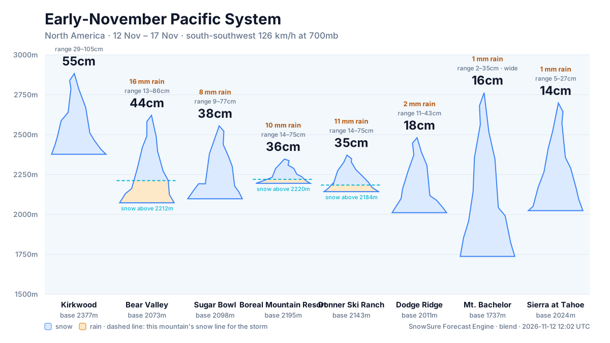
snowrain low, snow highraindryThe dots are the freeze line — the height where rain turns to snow. Solid: straight from the models. Hollow: estimated from temperature. Above the summit line it rains on the whole mountain; below the base line it snows all the way down. Blue bars are snow in cm, amber bars rain in mm; the totals above are their sums.
Rain / snow line
Base to summit for each mountain, with the snow line cut across them.
The system
700mb flow — where the storm is, and what is steering it. Pins sized by forecast total.
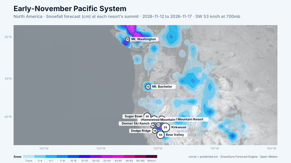
72-hour snowfall forecast for the same window.

In the path
Forecast, not observation — none of this has fallen yet. Totals are across the window. We will post what fell when the window closes.
 LiveKirkwoodbiggest day 34cm on 13 Nov · strengtheningPredicted55cm29–105cm across the models
 LiveBear Valleybiggest day 24cm on 13 Nov · strengtheningPredicted44cm13–86cm across the models
- Sugar Bowlbiggest day 23cm on 13 Nov · on trackPredicted38cm9–77cm across the models
LiveBoreal Mountain Resortbiggest day 21cm on 13 Nov · on trackPredicted36cm14–75cm across the models
- Donner Ski Ranchbiggest day 20cm on 13 Nov · on trackPredicted35cm14–75cm across the models
 LiveDodge Ridgebiggest day 16cm on 16 Nov · newPredicted18cm11–43cm across the models
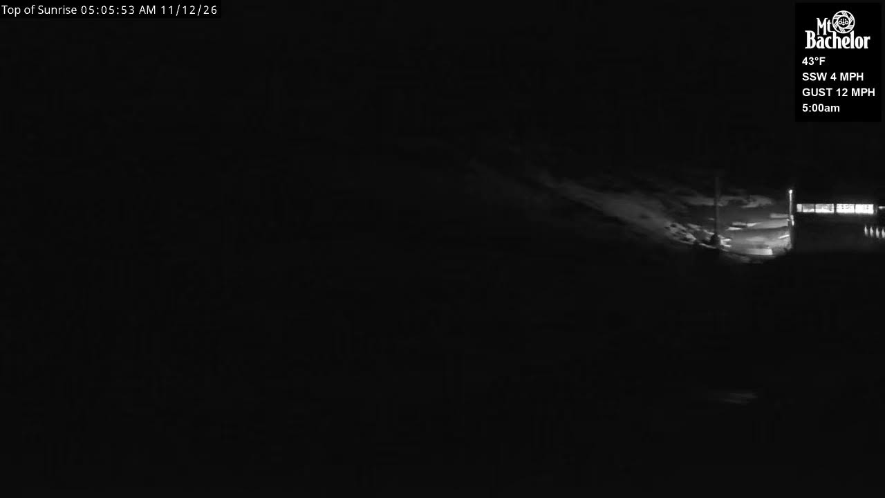 LiveMt. Bachelorbiggest day 7cm on 15 Nov · newPredicted16cm2–35cm, models far apart
LiveSierra at Tahoebiggest day 11cm on 16 Nov · delayedPredicted14cm5–27cm across the models
- Homewood Mountainbiggest day 10cm on 16 Nov · delayedPredicted12cm4–24cm across the models
LiveMt. Washingtonbiggest day 7cm on 15 Nov · strengtheningPredicted10cm0–57cm, models far apart
LiveNorthstar at Tahoebiggest day 7cm on 16 Nov · newPredicted10cm2–22cm, models far apart
 LiveMt. Bakerbiggest day 7cm on 16 Nov · strengtheningPredicted10cm3–26cm, models far apart
 LiveHeavenlybiggest day 7cm on 16 Nov · newPredicted8cm2–16cm across the models
 LiveMammoth Mountainbiggest day 5cm on 16 Nov · newPredicted7cm1–24cm, models far apart
Last updated 2026-11-07 00:30 UTC. SnowSure scans a blend of seven weather models twice daily and flags systems clearing 30cm over 72 hours, three to fourteen days out. This watch opened on 2026-11-03 with 87cm forecast at Kirkwood.


